Vexcel Data Program
  • Home
  • Products
    • Overview
    • Oblique
    • Ortho
    • 3D Cities
    • Elements
    • Elevate
    • Gray Sky
    • Multispectral
    • On Demand
  • Industries
    • Overview
    • Government
    • Telecom
    • Utilities
    • Insurance
      • Underwriting
      • Claims
      • SIU
    • Financial Services
    • Energy
    • AEC
    • HD Maps
    • Smart Cities
  • Coverage
  • Technology
    • Overview
    • Platform
      • MapControl SDK
      • Image Services for ArcGIS
    • Partners
    • Viewer
  • Stories
  • About
  • Login
  • Get a Demo
  • Menu Menu

Elevate Your Data with DSM & DTM

Get a clearer understanding of the earth’s surface and human-made objects with Vexcel Elevate, including Digital Surface Model (DSM) and Digital Terrain Model (DTM) data.

Urban & Wide Area Collections

30+ Countries

15-20cm spatial resolution for DTM

7.5cm spatial resolution for DSM

Transformational Data

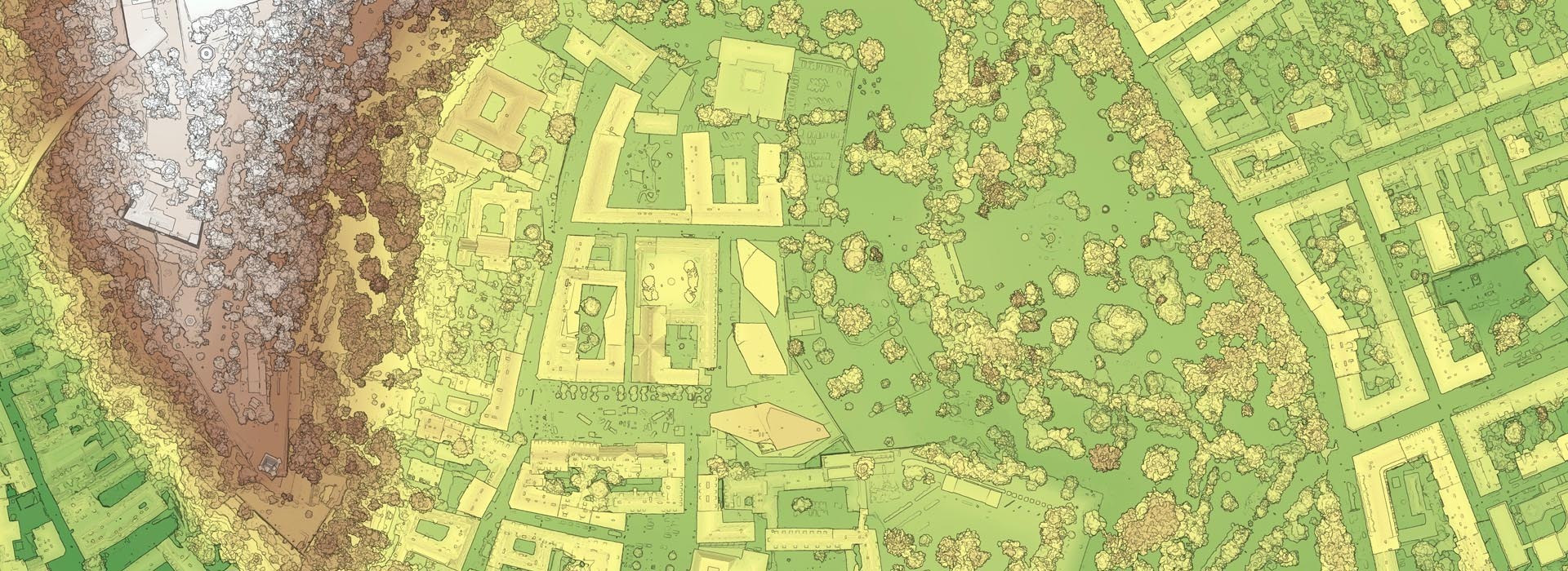
The rise of 3D data in GIS planning and mapping platforms indicates the growing need to have a stronger context and deeper understanding of the world around us. Digital Surface Model (DSM), Digital Terrain Model (DTM), and Digital Elevation Model (DEM) products tell the story of the earth’s surface, from capturing both natural/built features of the environment (DSM) to just natural/bare earth features (DTM/DEM).

Industries from Utilities to Transportation, Telecommunications to Government have recognized the value derived from DSM data. And since the quality of DSM products are measured by the accuracy of the elevation at each pixel, Vexcel’s aerial data supports highly precise DSM derived information.

Quick Access to DSM Data

DSM data is now more readily available via Vexcel’s API, allowing you to quickly access smaller chunks of data instead of massive megabytes of unwanted content. End users can select specific areas of interest and receive the data in a GeoTiff format via WMTS. The end result? More consumable DSM content in a file size that’s ready to be integrated into your third-party platform.

Did You Know?

Vexcel’s DSM has a pixel-to-data match with our True Ortho and Multispectral (NIR/CIR) imagery. The result? A perfect spatial alignment between elevation data and imagery for a more consistent and trusted output.

Greater Accuracy for Improved Analysis

Vexcel’s advanced camera systems capture more than just a pretty picture; they collect the elevation data simultaneously, resulting in a pixel-to-pixel match between the aerial image and DSM/DTM data for more accurate calculations. Apply filters to perform slope or surface analyses, quickly identify and differentiate ground or elevated features, and create output with desired object classifications, such as mapping solar panels or identifying objects between specific height parameters.

Smart City Planning with 3D Data

Creating a 3D digital representation of the earth can assist with smart urban planning as well as heritage conservation. DSM data can be used to solve challenges with urban development by generating 3D models of buildings, roads, and trees. Monuments or historical sites can be rendered for monitoring deterioration or development encroachment that could threaten preservation. Many GIS problems can be resolved with accurate DSM data.

Rolling Out 5G Networks with DSM

DSM data is helping transform the way network communications are being upgraded globally with 5G implementation. With the next generation of networks promising data speeds up to 50 times faster than 4G, 5G transmission demands shorter ranges between cell sites, a challenge in dense urban areas. Using DSM models of large cities, telecom companies can quickly identify where to install antennas with clear “lines of sight” between 5G sensors. This saves time and considerable cost for telecoms to identify these areas before sending out field operations teams to map the new network. They can create a plan that uses DSM data to identify what buildings or trees could impede a clear signal.

Bare Earth Data with DTM

Take out vegetation and built objects like trees and power lines with Digital Terrain Model data. Easily view  height and elevation of the bare earth as well as natural features like rivers and ridge lines. DTM information can be paired with DSMs to derive information such as height in a given area. Other uses include soil mapping, flood or drainage modeling, land use studies and other geological applications.

Request a Demo

Ready to see your area of interest? Fill out the Contact Us form to get connected to our team of experts so you can see firsthand how our imagery can change the way you work.

Contact Us

Products

Oblique
Ortho
3D Cities
Elements
Elevate
Gray Sky
Multispectral
On Demand

Coverage 
Countries

Industries

Government
Telecom
Utilities
Insurance
Financial Services
Energy
AEC
HD Maps
Smart Cities

Technology

Overview
Platform
Partners
Viewer

About
Stories
Videos
Careers
Help Center

Follow Us


Global Leaders in Aerial Imaging.

Vexcel provides industry-leading camera sensors, a dedicated fleet of fixed-wing aircraft, and the largest, most accurate aerial imagery and geospatial data program on the planet.

 width=

Large-format UltraCam cameras & sensors.
vexcel-imaging.com

Aerial surveys by fixed-wing aircraft.
kasurveys.com

Aerial imagery and data for government and business.
vexceldata.com

© Vexcel Imaging US, Inc.
  • Privacy Policy
  • Terms of Use
  • EULA
  • Worldwide
  • AU/NZ
Scroll to top

This site uses cookies. By continuing to browse the site, you are agreeing to our use of cookies.

Accept settingsHide notification onlySettings

Cookie and Privacy Settings


How we use cookies

We may request cookies to be set on your device. We use cookies to let us know when you visit our websites, how you interact with us, to enrich your user experience, and to customize your relationship with our website.

Click on the different category headings to find out more. You can also change some of your preferences. Note that blocking some types of cookies may impact your experience on our websites and the services we are able to offer.

Essential Website Cookies

These cookies are strictly necessary to provide you with services available through our website and to use some of its features.

Because these cookies are strictly necessary to deliver the website, refusing them will have impact how our site functions. You always can block or delete cookies by changing your browser settings and force blocking all cookies on this website. But this will always prompt you to accept/refuse cookies when revisiting our site.

We fully respect if you want to refuse cookies but to avoid asking you again and again kindly allow us to store a cookie for that. You are free to opt out any time or opt in for other cookies to get a better experience. If you refuse cookies we will remove all set cookies in our domain.

We provide you with a list of stored cookies on your computer in our domain so you can check what we stored. Due to security reasons we are not able to show or modify cookies from other domains. You can check these in your browser security settings.

Google Analytics Cookies

These cookies collect information that is used either in aggregate form to help us understand how our website is being used or how effective our marketing campaigns are, or to help us customize our website and application for you in order to enhance your experience.

If you do not want that we track your visit to our site you can disable tracking in your browser here:

Other external services

We also use different external services like Google Webfonts, Google Maps, and external Video providers. Since these providers may collect personal data like your IP address we allow you to block them here. Please be aware that this might heavily reduce the functionality and appearance of our site. Changes will take effect once you reload the page.

Google Webfont Settings:

Google Map Settings:

Google reCaptcha Settings:

Vimeo and Youtube video embeds:

Other cookies

The following cookies are also needed - You can choose if you want to allow them:

Privacy Policy

You can read about our cookies and privacy settings in detail on our Privacy Policy Page.

Accept settingsHide notification only