 https://vexceldata.com/wp-content/uploads/2024/12/AL-feature.jpg
720
1280
vexcel
https://vexceldata.com/wp-content/uploads/2021/12/VEXCEL-Data-Program.png
vexcel2025-01-27 16:32:532025-08-25 12:22:56The Untapped Value of Imagery Data in Financial Services
https://vexceldata.com/wp-content/uploads/2024/12/AL-feature.jpg
720
1280
vexcel
https://vexceldata.com/wp-content/uploads/2021/12/VEXCEL-Data-Program.png
vexcel2025-01-27 16:32:532025-08-25 12:22:56The Untapped Value of Imagery Data in Financial Services https://vexceldata.com/wp-content/uploads/2024/10/Hurricane-Milton-St_Petersburg_FL_27.768165_-82.654007-1500x844-1.jpg
844
1500
jody
https://vexceldata.com/wp-content/uploads/2021/12/VEXCEL-Data-Program.png
jody2024-10-07 15:48:042024-10-07 15:48:04Gray Sky Event: Hurricane Milton
https://vexceldata.com/wp-content/uploads/2024/10/Hurricane-Milton-St_Petersburg_FL_27.768165_-82.654007-1500x844-1.jpg
844
1500
jody
https://vexceldata.com/wp-content/uploads/2021/12/VEXCEL-Data-Program.png
jody2024-10-07 15:48:042024-10-07 15:48:04Gray Sky Event: Hurricane Milton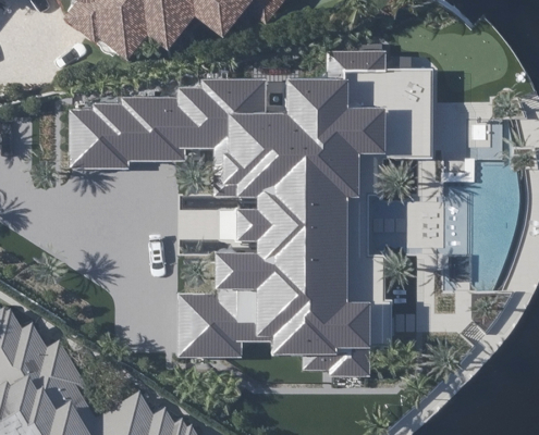 https://vexceldata.com/wp-content/uploads/2024/08/Boca_Raton_FL_USA_west_ortho_26.325454_-80.jpg
720
1280
jody
https://vexceldata.com/wp-content/uploads/2021/12/VEXCEL-Data-Program.png
jody2024-10-02 09:51:182025-04-21 14:31:05The Importance of Ground Control Points and Accuracy in Aerial Imagery
https://vexceldata.com/wp-content/uploads/2024/08/Boca_Raton_FL_USA_west_ortho_26.325454_-80.jpg
720
1280
jody
https://vexceldata.com/wp-content/uploads/2021/12/VEXCEL-Data-Program.png
jody2024-10-02 09:51:182025-04-21 14:31:05The Importance of Ground Control Points and Accuracy in Aerial Imagery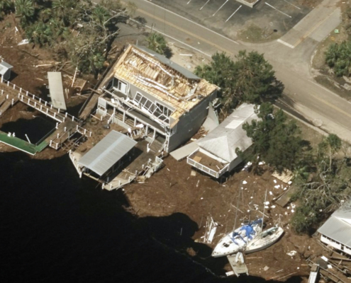 https://vexceldata.com/wp-content/uploads/2024/10/Hurricane-Helene-Steinhatchee-FL_29.670209_-83.383148.jpg
1152
2048
jody
https://vexceldata.com/wp-content/uploads/2021/12/VEXCEL-Data-Program.png
jody2024-09-26 15:57:492024-09-26 15:57:49Gray Sky: Hurricane Helene
https://vexceldata.com/wp-content/uploads/2024/10/Hurricane-Helene-Steinhatchee-FL_29.670209_-83.383148.jpg
1152
2048
jody
https://vexceldata.com/wp-content/uploads/2021/12/VEXCEL-Data-Program.png
jody2024-09-26 15:57:492024-09-26 15:57:49Gray Sky: Hurricane Helene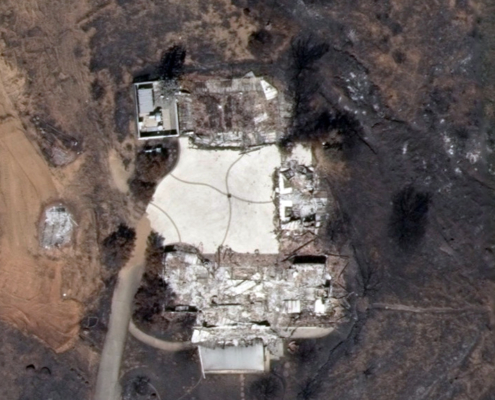 https://vexceldata.com/wp-content/uploads/2024/11/33.651434-117.420934-AFter.jpg
576
1024
jody
https://vexceldata.com/wp-content/uploads/2021/12/VEXCEL-Data-Program.png
jody2024-09-19 08:27:482024-11-01 16:09:47Gray Sky: Trabuco Canyon – Airport Fire in CA
https://vexceldata.com/wp-content/uploads/2024/11/33.651434-117.420934-AFter.jpg
576
1024
jody
https://vexceldata.com/wp-content/uploads/2021/12/VEXCEL-Data-Program.png
jody2024-09-19 08:27:482024-11-01 16:09:47Gray Sky: Trabuco Canyon – Airport Fire in CA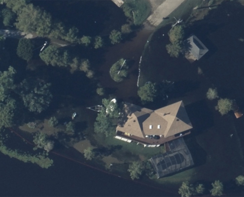 https://vexceldata.com/wp-content/uploads/2024/09/30.260490-89.828640-Slidell-After.jpg
576
1024
vexcel
https://vexceldata.com/wp-content/uploads/2021/12/VEXCEL-Data-Program.png
vexcel2024-09-15 08:20:562024-11-05 15:09:07Gray Sky: the Aftermath of Hurricane Francine
https://vexceldata.com/wp-content/uploads/2024/09/30.260490-89.828640-Slidell-After.jpg
576
1024
vexcel
https://vexceldata.com/wp-content/uploads/2021/12/VEXCEL-Data-Program.png
vexcel2024-09-15 08:20:562024-11-05 15:09:07Gray Sky: the Aftermath of Hurricane Francine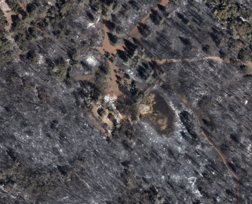 https://vexceldata.com/wp-content/uploads/2024/08/park-fire-after.jpg
1051
2048
kris.wagner
https://vexceldata.com/wp-content/uploads/2021/12/VEXCEL-Data-Program.png
kris.wagner2024-08-09 08:44:062024-11-05 15:13:08Gray Sky Event: Park Fire
https://vexceldata.com/wp-content/uploads/2024/08/park-fire-after.jpg
1051
2048
kris.wagner
https://vexceldata.com/wp-content/uploads/2021/12/VEXCEL-Data-Program.png
kris.wagner2024-08-09 08:44:062024-11-05 15:13:08Gray Sky Event: Park Fire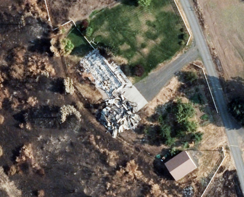 https://vexceldata.com/wp-content/uploads/2023/01/after1-borel-495x400-1.jpg
400
495
kris.wagner
https://vexceldata.com/wp-content/uploads/2021/12/VEXCEL-Data-Program.png
kris.wagner2024-08-05 21:27:462024-11-05 15:42:16Gray Sky Event: Borel Fire
https://vexceldata.com/wp-content/uploads/2023/01/after1-borel-495x400-1.jpg
400
495
kris.wagner
https://vexceldata.com/wp-content/uploads/2021/12/VEXCEL-Data-Program.png
kris.wagner2024-08-05 21:27:462024-11-05 15:42:16Gray Sky Event: Borel Fire https://vexceldata.com/wp-content/uploads/2024/08/gwen-fire.jpg
400
495
kris.wagner
https://vexceldata.com/wp-content/uploads/2021/12/VEXCEL-Data-Program.png
kris.wagner2024-08-03 06:38:552024-11-05 15:41:52Gray Sky Event: Gwen Fire
https://vexceldata.com/wp-content/uploads/2024/08/gwen-fire.jpg
400
495
kris.wagner
https://vexceldata.com/wp-content/uploads/2021/12/VEXCEL-Data-Program.png
kris.wagner2024-08-03 06:38:552024-11-05 15:41:52Gray Sky Event: Gwen Fire
