High Resolution & Accurate
Aerial Imagery for Electric Utilities
Imagery and elevation models to support vegetation management, network asset inspection, disaster response, and grid maintenance planning.

Imagery and elevation models to support vegetation management, network asset inspection, disaster response, and grid maintenance planning.
Imagery and elevation models to support vegetation management, asset inspection, disaster response, and grid and maintenance planning.
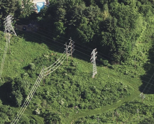
Managing hundreds of thousands of miles of transmission and distribution infrastructure requires visibility that traditional methods alone can’t deliver. Wildfire liability is intensifying. NERC compliance scrutiny is tightening. And your teams need a geo foundation that feeds asset management, analytics, and storm response simultaneously.
Vexcel provides a complete data stack engineered for utilities: high-resolution imagery, elevation models, and multispectral data across your entire service territory—all aligned, all current, one vendor. This becomes your foundation for vegetation risk management, timestamped evidence for compliance documentation, rapid damage assessment after major storms, asset prioritization, and AI-driven operations.
Our aerial imagery library covers your whole network, from city substations to rural transmission corridors. With ongoing collection programs and a historical imagery library, you can review assets across your service territory and compare imagery over time to identify changes.
Vexcel’s imagery is matched to ground control points and produced to ASPRS standards, delivering highly accurate, timestamped imagery that supports engineering, compliance, and regulatory reporting.


Vegetation height. Asset elevation. Terrain exposure. Vexcel’s Digital Surface Model (DSM) gives you the elevation data to better understand your network.
Captured alongside our ortho and multispectral imagery, Vexcel’s DSM delivers accurate elevation data that aligns directly with what you see on the ground. It’s a cost-effective way to augment—or, in some cases, replace—LiDAR collections while providing territory-wide coverage and ongoing updates.
Oblique views at 45-degree angles let your teams visually inspect poles, substations, and transmission corridors from multiple directions.
You can remotely measure pole heights, assess equipment and attachments, evaluate vegetation proximity, and see surrounding conditions.
From north, east, south, and west views, your GIS and engineering teams see what’s actually there and make confident decisions about condition, maintenance priorities, and investment needs.


Standard aerial RGB imagery shows you where vegetation is. Multispectral imagery helps reveal which vegetation poses the greatest risk and why.
Vexcel’s color-infrared (CIR) imagery makes it easy to distinguish healthy, stressed, and dying trees, helping you identify vegetation risks and detect encroachment into utility corridors and clearance zones.
Search your entire network in seconds. Vexcel Intelligence lets you search Vexcel’s multi-modal data using natural language.
Ask questions like:
Search in Vexcel Studio or bring the same real-world intelligence into AI apps like Claude and ChatGPT.


After a major hurricane, wildfire, or tornado, it can take days to understand the full extent of the impact across your service territory.
Vexcel’s Gray Sky program captures high-resolution aerial imagery after major catastrophic events, showing the actual extent of damage and affected infrastructure.
Combined with pre-disaster baseline imagery, you can quickly compare before-and-after conditions to assess impacts, document damage, and support recovery planning.
 https://vexceldata.com/wp-content/uploads/2026/02/42.604603-73.798436-PowerLine-Glenmont-NY-2022.jpg
576
1024
vexcel
https://vexceldata.com/wp-content/uploads/2021/12/VEXCEL-Data-Program.png
vexcel2026-02-05 10:00:372026-06-23 17:01:28Spot the Spark Before it Starts
https://vexceldata.com/wp-content/uploads/2026/02/42.604603-73.798436-PowerLine-Glenmont-NY-2022.jpg
576
1024
vexcel
https://vexceldata.com/wp-content/uploads/2021/12/VEXCEL-Data-Program.png
vexcel2026-02-05 10:00:372026-06-23 17:01:28Spot the Spark Before it Starts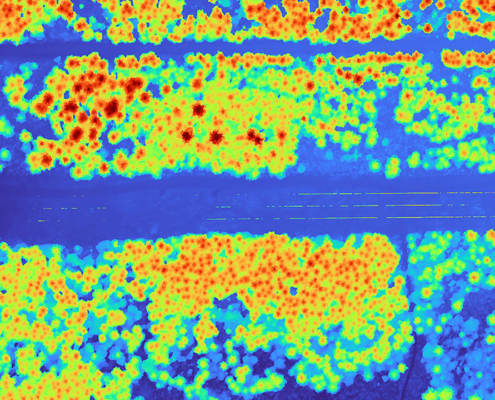 https://vexceldata.com/wp-content/uploads/2025/05/Ravensdale-WA-47.364353-121.950564-DSM.jpg
720
1280
vexcel
https://vexceldata.com/wp-content/uploads/2021/12/VEXCEL-Data-Program.png
vexcel2025-05-05 10:45:022026-06-23 17:04:36High-res Imagery & DSM for Utilities Vegetation Management
https://vexceldata.com/wp-content/uploads/2025/05/Ravensdale-WA-47.364353-121.950564-DSM.jpg
720
1280
vexcel
https://vexceldata.com/wp-content/uploads/2021/12/VEXCEL-Data-Program.png
vexcel2025-05-05 10:45:022026-06-23 17:04:36High-res Imagery & DSM for Utilities Vegetation Management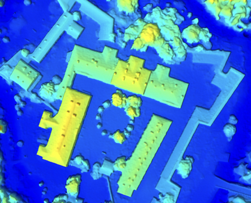 https://vexceldata.com/wp-content/uploads/2025/02/60.144978-24.984679_Finland-DSM.jpg
576
1024
vexcel
https://vexceldata.com/wp-content/uploads/2021/12/VEXCEL-Data-Program.png
vexcel2025-03-10 11:16:542026-06-24 09:31:11Evaluating DSM and its Origin Source: LiDAR or Photogrammetry
https://vexceldata.com/wp-content/uploads/2025/02/60.144978-24.984679_Finland-DSM.jpg
576
1024
vexcel
https://vexceldata.com/wp-content/uploads/2021/12/VEXCEL-Data-Program.png
vexcel2025-03-10 11:16:542026-06-24 09:31:11Evaluating DSM and its Origin Source: LiDAR or Photogrammetry![]()
Large-format UltraCam cameras & sensors.
vexcel-imaging.com
Aerial surveys by fixed-wing aircraft.
kasurveys.com
Aerial imagery and data for government and business.
vexceldata.com