Capturing the World. Powering What’s Next.
Camera sensors. A global fleet of aircraft. Aerial imagery. Geospatial data. AI. Vexcel delivers it all—at unmatched scale.

At Vexcel, we capture imagery and data of the real world so people can understand it better. We design the market-leading UltraCam sensors, mount them on a global fleet of aircraft, and fly year-round to collect high-resolution imagery and data.
Those collections feed into the world’s largest aerial imagery and data program, spanning more than 40 countries and territories with petabytes of content. No other aerial program matches Vexcel’s resolution, accuracy, consistency, scale, or refresh rate. With nearly 500 employees worldwide, Vexcel turns raw pixels into trusted intelligence.
The world’s top companies depend on Vexcel’s data, as do government agencies and organizations across the private sector. Vexcel also fuels the next generation of AI with best-in-class information from the real world.

Market-leading UltraCam large-format cameras and sensors, paired with UltraMap photogrammetric software for end-to-end imagery processing.

A dedicated fleet of aircraft and trusted third-party fliers collecting aerial data year-round, with both ongoing programs and on-demand collections.

The world’s largest aerial imagery program, covering 40+ countries and territories and delivering high-res imagery and data at unmatched accuracy and scale.
Vexcel has nearly 500 employees working in offices or remotely across the globe. Our corporate offices are located at:


Join a team that’s capturing the real world and transforming it into intelligence for people and AI. Vexcel offers opportunities to work with cutting-edge technology, global datasets, and a mission that makes an impact worldwide.
Explore open roles:

 https://vexceldata.com/wp-content/uploads/2026/03/North-Plantations-WA-24.848160-113.668405-1.jpg
720
1280
kris.wagner
https://vexceldata.com/wp-content/uploads/2021/12/VEXCEL-Data-Program.png
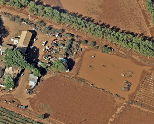
kris.wagner2026-03-31 11:10:292026-04-01 18:25:06Gray Sky: Cyclone Narelle, Australia
https://vexceldata.com/wp-content/uploads/2026/03/North-Plantations-WA-24.848160-113.668405-1.jpg
720
1280
kris.wagner
https://vexceldata.com/wp-content/uploads/2021/12/VEXCEL-Data-Program.png
kris.wagner2026-03-31 11:10:292026-04-01 18:25:06Gray Sky: Cyclone Narelle, Australia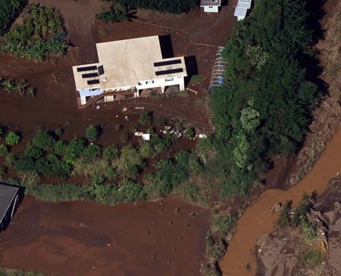 https://vexceldata.com/wp-content/uploads/2026/03/gray-sky-hawaii-floods_21.565033_-158.118269.jpg
720
1280
vexcel
https://vexceldata.com/wp-content/uploads/2021/12/VEXCEL-Data-Program.png
vexcel2026-03-31 07:46:422026-03-31 10:02:21Gray Sky: Hawaii Floods
https://vexceldata.com/wp-content/uploads/2026/03/gray-sky-hawaii-floods_21.565033_-158.118269.jpg
720
1280
vexcel
https://vexceldata.com/wp-content/uploads/2021/12/VEXCEL-Data-Program.png
vexcel2026-03-31 07:46:422026-03-31 10:02:21Gray Sky: Hawaii Floods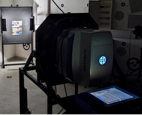 https://vexceldata.com/wp-content/uploads/2026/02/Color-Calibration-Sensors.jpg
831
1265
vexcel
https://vexceldata.com/wp-content/uploads/2021/12/VEXCEL-Data-Program.png
vexcel2026-03-17 10:57:362026-03-17 10:58:16Color That Counts: Why Calibration Matters
https://vexceldata.com/wp-content/uploads/2026/02/Color-Calibration-Sensors.jpg
831
1265
vexcel
https://vexceldata.com/wp-content/uploads/2021/12/VEXCEL-Data-Program.png
vexcel2026-03-17 10:57:362026-03-17 10:58:16Color That Counts: Why Calibration Matters![]()
Large-format UltraCam cameras & sensors.
vexcel-imaging.com
Aerial surveys by fixed-wing aircraft.
kasurveys.com
Aerial imagery and data for government and business.
vexceldata.com