 https://vexceldata.com/wp-content/uploads/2022/03/2022-03-08-at-2.56-PM.jpg
725
1438
Amanda Smith
https://vexceldata.com/wp-content/uploads/2021/12/VEXCEL-Data-Program.png
Amanda Smith2022-03-09 17:11:482022-03-28 09:12:46The Latest Enhancements to Viewer
https://vexceldata.com/wp-content/uploads/2022/03/2022-03-08-at-2.56-PM.jpg
725
1438
Amanda Smith
https://vexceldata.com/wp-content/uploads/2021/12/VEXCEL-Data-Program.png
Amanda Smith2022-03-09 17:11:482022-03-28 09:12:46The Latest Enhancements to Viewer https://vexceldata.com/wp-content/uploads/2022/02/Image-from-iOS-5-scaled.jpg
2560
1920
Angie Brewster
https://vexceldata.com/wp-content/uploads/2021/12/VEXCEL-Data-Program.png
Angie Brewster2022-02-11 21:33:572022-02-21 19:00:02Geo Week 2022 Showcases New SDK, Growing Imagery Library, and Integration Updates
https://vexceldata.com/wp-content/uploads/2022/02/Image-from-iOS-5-scaled.jpg
2560
1920
Angie Brewster
https://vexceldata.com/wp-content/uploads/2021/12/VEXCEL-Data-Program.png
Angie Brewster2022-02-11 21:33:572022-02-21 19:00:02Geo Week 2022 Showcases New SDK, Growing Imagery Library, and Integration Updates https://vexceldata.com/wp-content/uploads/2022/02/Elements1.png
348
754
Steve Lombardi
https://vexceldata.com/wp-content/uploads/2021/12/VEXCEL-Data-Program.png
Steve Lombardi2022-02-10 18:36:322022-03-10 17:35:25Building Geometry and Property Attributes? It’s Elements-ary, dear Watson
https://vexceldata.com/wp-content/uploads/2022/02/Elements1.png
348
754
Steve Lombardi
https://vexceldata.com/wp-content/uploads/2021/12/VEXCEL-Data-Program.png
Steve Lombardi2022-02-10 18:36:322022-03-10 17:35:25Building Geometry and Property Attributes? It’s Elements-ary, dear Watson https://vexceldata.com/wp-content/uploads/2022/01/36.163623-86.776919-scaled.jpg
1440
2560
Angie Brewster
https://vexceldata.com/wp-content/uploads/2021/12/VEXCEL-Data-Program.png
Angie Brewster2022-01-25 17:03:562022-01-25 17:03:56How the Tennessee State Government is Using High-Res Aerial Imagery to Streamline 911 Response
https://vexceldata.com/wp-content/uploads/2022/01/36.163623-86.776919-scaled.jpg
1440
2560
Angie Brewster
https://vexceldata.com/wp-content/uploads/2021/12/VEXCEL-Data-Program.png
Angie Brewster2022-01-25 17:03:562022-01-25 17:03:56How the Tennessee State Government is Using High-Res Aerial Imagery to Streamline 911 Response https://vexceldata.com/wp-content/uploads/2022/01/Part2_blog_Pic29.png
713
1195
Angie Brewster
https://vexceldata.com/wp-content/uploads/2021/12/VEXCEL-Data-Program.png
Angie Brewster2022-01-07 19:57:512022-02-10 13:14:06Let’s get technical (Pt 2): Using Python data science libraries on web map tiles
https://vexceldata.com/wp-content/uploads/2022/01/Part2_blog_Pic29.png
713
1195
Angie Brewster
https://vexceldata.com/wp-content/uploads/2021/12/VEXCEL-Data-Program.png
Angie Brewster2022-01-07 19:57:512022-02-10 13:14:06Let’s get technical (Pt 2): Using Python data science libraries on web map tiles https://vexceldata.com/wp-content/uploads/2021/12/Screen-Shot-2021-12-28-at-3.06.32-PM.png
1302
2156
Angie Brewster
https://vexceldata.com/wp-content/uploads/2021/12/VEXCEL-Data-Program.png
Angie Brewster2021-12-28 22:12:572021-12-29 15:26:51Pasco Corp Announced as Reseller of Urban Vexcel Data in Japan
https://vexceldata.com/wp-content/uploads/2021/12/Screen-Shot-2021-12-28-at-3.06.32-PM.png
1302
2156
Angie Brewster
https://vexceldata.com/wp-content/uploads/2021/12/VEXCEL-Data-Program.png
Angie Brewster2021-12-28 22:12:572021-12-29 15:26:51Pasco Corp Announced as Reseller of Urban Vexcel Data in Japan https://vexceldata.com/wp-content/uploads/2021/12/Screen-Shot-2021-12-22-at-9.45.19-AM.png
692
697
Angie Brewster
https://vexceldata.com/wp-content/uploads/2021/12/VEXCEL-Data-Program.png
Angie Brewster2021-12-22 17:00:202022-02-10 13:06:32Let’s get technical: Using Web Map Tiles in Python (Pt 1)
https://vexceldata.com/wp-content/uploads/2021/12/Screen-Shot-2021-12-22-at-9.45.19-AM.png
692
697
Angie Brewster
https://vexceldata.com/wp-content/uploads/2021/12/VEXCEL-Data-Program.png
Angie Brewster2021-12-22 17:00:202022-02-10 13:06:32Let’s get technical: Using Web Map Tiles in Python (Pt 1) https://vexceldata.com/wp-content/uploads/2021/12/Screen-Shot-2021-12-22-at-9.19.55-AM.png
954
940
Angie Brewster
https://vexceldata.com/wp-content/uploads/2021/12/VEXCEL-Data-Program.png
Angie Brewster2021-12-21 18:42:532022-02-10 13:16:402021 – A Year Full of Announcements
https://vexceldata.com/wp-content/uploads/2021/12/Screen-Shot-2021-12-22-at-9.19.55-AM.png
954
940
Angie Brewster
https://vexceldata.com/wp-content/uploads/2021/12/VEXCEL-Data-Program.png
Angie Brewster2021-12-21 18:42:532022-02-10 13:16:402021 – A Year Full of Announcements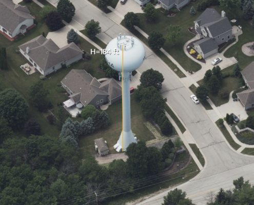 https://vexceldata.com/wp-content/uploads/2021/11/Screen-Shot-2021-11-05-at-1.01.10-PM.png
1650
3542
Rob Carroll
https://vexceldata.com/wp-content/uploads/2021/12/VEXCEL-Data-Program.png
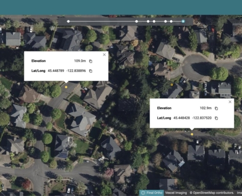
Rob Carroll2021-11-03 15:38:012022-05-16 22:25:17The Value of 3D Measurement – Tools Ready to Use
https://vexceldata.com/wp-content/uploads/2021/11/Screen-Shot-2021-11-05-at-1.01.10-PM.png
1650
3542
Rob Carroll
https://vexceldata.com/wp-content/uploads/2021/12/VEXCEL-Data-Program.png
Rob Carroll2021-11-03 15:38:012022-05-16 22:25:17The Value of 3D Measurement – Tools Ready to Use