Post-Disaster Rapid Response
Gray Sky Imagery
High-resolution aerial imagery collected after hurricanes, wildfires, tornadoes, and other catastrophes to support emergency response, insurance claims, and community recovery.

High-resolution aerial imagery collected after hurricanes, wildfires, tornadoes, and other catastrophes to support emergency response, insurance claims, and community recovery.
Using a nimble fleet of well-positioned aircraft across the U.S., Vexcel captures, processes, and delivers disaster imagery shortly after major disasters occur. Additionally, Vexcel offers on-demand disaster collections in select countries. Bushfires in Australia, hurricanes in Puerto Rico, and even floods in Germany have been collected with the on-demand program.

Using a nimble fleet of well-positioned aircraft across the U.S., Vexcel captures, processes, and delivers disaster imagery shortly after major disasters occur. Additionally, Vexcel offers on-demand disaster collections in select countries. Bushfires in Australia, hurricanes in Puerto Rico, and even floods in Germany have been collected with the on-demand program.

Using a nimble fleet of well-positioned aircraft across the U.S., Vexcel captures, processes, and delivers disaster imagery shortly after major disasters occur. Additionally, Vexcel offers on-demand disaster collections in select countries. Bushfires in Australia, hurricanes in Puerto Rico, and even floods in Germany have been collected with the on-demand program.

Using a nimble fleet of well-positioned aircraft across the U.S., Vexcel captures, processes, and delivers disaster imagery shortly after major disasters occur. Additionally, Vexcel offers on-demand disaster collections in select countries. Bushfires in Australia, hurricanes in Puerto Rico, and even floods in Germany have been collected with the on-demand program.

Vexcel focuses on disasters that impact commercial and residential properties across the United States, focusing on hurricanes, tornadoes, and wildfires. By providing high-resolution aerial imagery that is significantly more detailed than satellite, larger in scale and coverage than drone, our customers get a more accurate sense of the true impact of a measurable catastrophic event.

Vexcel focuses on disasters that impact commercial and residential properties across the United States, focusing on hurricanes, tornadoes, and wildfires. By providing high-resolution aerial imagery that is significantly more detailed than satellite, larger in scale and coverage than drone, our customers get a more accurate sense of the true impact of a measurable catastrophic event.

Vexcel focuses on disasters that impact commercial and residential properties across the United States, focusing on hurricanes, tornadoes, and wildfires. By providing high-resolution aerial imagery that is significantly more detailed than satellite, larger in scale and coverage than drone, our customers get a more accurate sense of the true impact of a measurable catastrophic event.

Disaster response has been fundamentally changed through the application of artificial intelligence (AI). Within seconds, end users get auto-generated property and building information all pulled from best-in-class, high-resolution imagery. Quickly view disaster details such as an overall catastrophe (CAT) score, approximate FEMA score, and more. Use with Vexcel’s Blue Sky (pre-disaster) for comparison.
GALLERY: 1) View Damage Assessment on a home impacted by Hurricane Milton, 2), Damage analysis of Lahaina wildfire in Maui, and 3) Before-After-After on home impacted by Hurricane Ian

Vexcel provides aerial imagery to dozens of insurance companies. The timestamped imagery aids in their claim and SIU assessment, triaging, and informing adjusters on the ground. Gray Sky imagery also supports emergency managers and government agencies to help prioritize relief efforts, allocate resources effectively, and more. Utility and Telecom companies have utilized Vexcel’s aerial imagery to assess impacted areas and identify infrastructure damage or outages to restore services efficiently, and minimize disruption for affected communities.

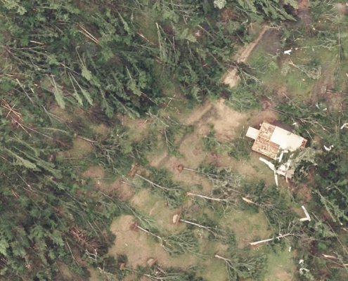 https://vexceldata.com/wp-content/uploads/2026/05/gray-sky-mississippi-tornado_31.361466_-91.125327.jpg
720
1280
kris.wagner
https://vexceldata.com/wp-content/uploads/2021/12/VEXCEL-Data-Program.png
kris.wagner2026-05-09 08:25:012026-05-14 07:20:41Gray Sky: Mississippi Tornadoes
https://vexceldata.com/wp-content/uploads/2026/05/gray-sky-mississippi-tornado_31.361466_-91.125327.jpg
720
1280
kris.wagner
https://vexceldata.com/wp-content/uploads/2021/12/VEXCEL-Data-Program.png
kris.wagner2026-05-09 08:25:012026-05-14 07:20:41Gray Sky: Mississippi Tornadoes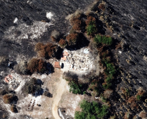 https://vexceldata.com/wp-content/uploads/2026/04/southeast-ga-fires-31.214744_-81.835177.jpg
720
1280
kris.wagner
https://vexceldata.com/wp-content/uploads/2021/12/VEXCEL-Data-Program.png
kris.wagner2026-04-26 13:15:492026-05-01 10:55:02Gray Sky: Southeast Georgia Fires
https://vexceldata.com/wp-content/uploads/2026/04/southeast-ga-fires-31.214744_-81.835177.jpg
720
1280
kris.wagner
https://vexceldata.com/wp-content/uploads/2021/12/VEXCEL-Data-Program.png
kris.wagner2026-04-26 13:15:492026-05-01 10:55:02Gray Sky: Southeast Georgia Fires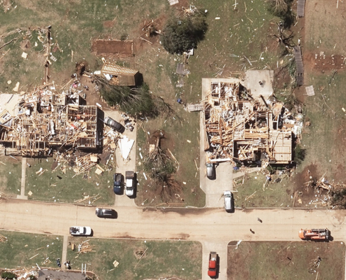 https://vexceldata.com/wp-content/uploads/2026/04/gray-sky-enid-ok_36.338195-97.886121.jpg
700
1280
kris.wagner
https://vexceldata.com/wp-content/uploads/2021/12/VEXCEL-Data-Program.png
kris.wagner2026-04-25 07:08:052026-04-26 12:32:19Gray Sky: Enid, Oklahoma Tornado
https://vexceldata.com/wp-content/uploads/2026/04/gray-sky-enid-ok_36.338195-97.886121.jpg
700
1280
kris.wagner
https://vexceldata.com/wp-content/uploads/2021/12/VEXCEL-Data-Program.png
kris.wagner2026-04-25 07:08:052026-04-26 12:32:19Gray Sky: Enid, Oklahoma Tornado![]()
Large-format UltraCam cameras & sensors.
vexcel-imaging.com
Aerial surveys by fixed-wing aircraft.
kasurveys.com
Aerial imagery and data for government and business.
vexceldata.com