Calculate Building Geometry Using Vexcel Elements: Property Attributes
January brought in the new year and a powerful new data product in our toolbox: Vexcel Elements featuring Property Attributes. With Elements, you have access to the geometry of each building and over 20 attributes about the building and property.
Elements uses a powerful machine learning model to extract the geometry of a building from our high-resolution imagery. Additionally, we extract attributes about the building, such as roof material, roof condition, solar panels, and tree coverage. Other attributes related to the property itself are also available, including the presence of a pool or trampoline. Currently, over 20 attributes for each property are provided.
Elements is available wherever Vexcel has imagery coverage, including our 7.5cm urban (Oblique and True Ortho) AND our wide area coverage (Ortho)! Where urban imagery is available, Elements property information is pre-calculated and available with sub-second response times.
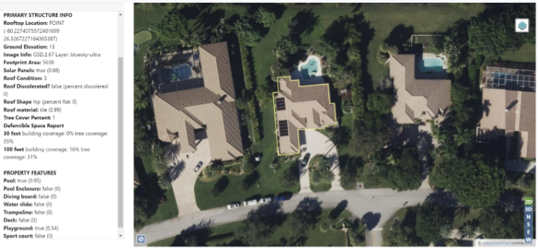
In the screenshot below, you can see the footprint drawn as a yellow outline over the basemap image, along with the full set of per-property attributes in the left rail. If you look closely to the right side of the building you will see the small playground reported by the system.
The application development options with Elements are boundless. Here are a few use cases to get you started planning your application or integration.
- Use the building geometry to constrain calculations to a building’s bounds. For instance, in performing damage analysis after a storm, you can limit the computer vision to just analyze the pixels that make up the roof of the target property, ignoring conditions on neighboring rooftops.
- Use the geometry to cookie cut our Digital Surface Model allowing for creation of fast 3D models.
- Use attributes in decision-making pipelines. Insurance underwriting can take advantage of roof condition, tree coverage and defensible space data to automate pricing for underwriting.
- Unlock historic analysis with our year-over-year imagery collections. By default, the most recent imagery is used in the analysis of a given property. You can specify an older collection of imagery to be used in creation of the footprint and attributes. This makes it easy to compare current conditions with those from past collections.
Rest API Walkthrough
The first means of accessing this data is via our REST API. With this API, you pass a coordinate and the platform returns the property record at that coordinate. In the future there will be other services fronting this data set allowing for integration into GIS systems and other workflows. We’ll have a Vector tile layer available for visualization in GIS platforms as well as additional API parameters to provide more flexibility in filtering and requesting multiple records at once.
Let’s take a look at how to use the API. In this walkthrough, we’ll request a Property Information record, then use the returned building geometry in a follow up call to the ExtractOrthoImage API to get a high-resolution image of the property.
For the Property Information call we are going to use the most common calling pattern, which is a single API call with the JSON response containing the data. In addition to this pattern, there are options to specify a callback URL to have the response data posted, or you can make a follow up call to the getStatus() method to retrieve the response asynchronously. This comes in handy when building server side applications where you don’t want to wait while property information is being calculated. Details for these patterns are covered in the documentation for GetPropertyInformation.
Step-by-step process
- Generate an authentication token.
The first step in any application built with the Vexcel REST API is to generate an authentication token that you’ll pass to all subsequent calls. Use the login endpoint to do so, passing your UserID and Password. - Make an API call for Property Information.
Next we’ll call the GetPropertyInformation service, passing the coordinate from which we want to query. The ‘wkt’ parameter will specify the coordinate. The ‘token’ parameter is also required and contains the auth token we generated a moment ago. Our call will look like this:
The JSON response contains all of the attributes about the building and property, along with a Well Known Text (WKT) representation of the building geometry. Let’s take a look at some of the key attributes in the response.
Most attributes will have a value and a score, like this:
This next portion of the response is telling us that 1% of the roof has tree branches hanging over the roof area.
3. Make an API call to retrieve imagery of the property
The object contains an area attribute with the square footage of the building, along with the wkt attribute containing the geometry of the footprint. It looks like this:
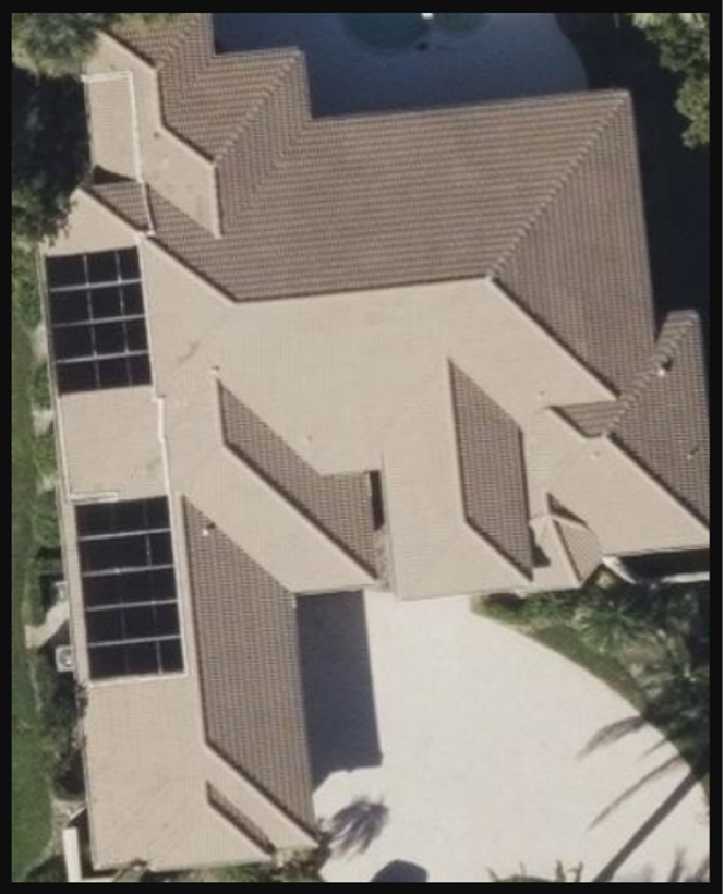
One common use of this wkt is to pass it as a parameter to ExtractOrthoImages. The resulting image will be tightly fitted to the footprint. Here is an example of that call and the resulting image:
Get Started Today
We hope that this introduction to Vexcel Elements: Property Attributes was helpful in getting started. Be sure to dig into the online documentation to learn about all of the attributes in the response, as well as the other patterns for calling the API. We look forward to hearing about your experience with this new API. Drop us an email at support@vexcelgroup.com with any questions.


