High Resolution & Accurate
Aerial Imagery for Property Assessment
Frequently updated imagery and geospatial data to help tax assessors visualize properties, track changes, and support accurate valuations.
Frequently updated imagery and geospatial data to help tax assessors visualize properties, track changes, and support accurate valuations.
Vexcel delivers high-resolution aerial imagery and geospatial data across urban and rural areas in 49 states, covering 99.6% of the U.S. population. Imagery is also available in 40+ countries.
Access off-the-shelf imagery with regular updates and historical views to support accurate property assessments. Enhance your workflows with AI-derived property attributes and detailed change detection—all available for your county, city, region, or tax jurisdiction.
Monitor new construction and land development with high-resolution aerial imagery. This example shows the progression of a neighborhood build-out, collected over time using Vexcel’s consistent imagery program.
Tax assessors use our imagery to detect property changes, verify assessments, and update records with confidence. With historical and current views, you can easily identify new structures, additions, or land use changes across entire communities.
Get a complete view of any property with north, east, south, and west oblique imagery.
Available in urban areas around the globe and in more than 3,300 cities across the U.S., Vexcel’s Oblique imagery gives tax assessors a side-angle perspective not available in top-down or street-view images. Oblique views reveal critical property details such as building stories, roof features, overhangs, decks, patios, garages, and additions.
This angle also improves visibility of structures partially blocked by trees or neighboring buildings. Use oblique imagery to improve assessment accuracy, reduce field visits, and support efficient remote inspections.
Get a complete view of any property with north, south, east, and west oblique imagery.
Available in urban areas around the globe and in more than 3,300 cities across the U.S., Vexcel’s oblique imagery gives tax assessors a side-angle perspective not available in top-down or street-view images. Oblique views reveal critical property details such as building stories, roof features, overhangs, decks, patios, garages, and additions.
This angle also improves visibility of structures partially blocked by trees or neighboring buildings. Use oblique imagery to improve assessment accuracy, reduce field visits, and support efficient remote inspections.
See key changes and capture property details using Elements AI: Property Attributes. This dataset, extracted from Vexcel’s high-resolution aerial imagery, helps identify additions, patios, decks, pools, garages, and building footprints.
Tax assessors use this information to flag property changes, update records, and support accurate, remote assessments without needing a site visit.
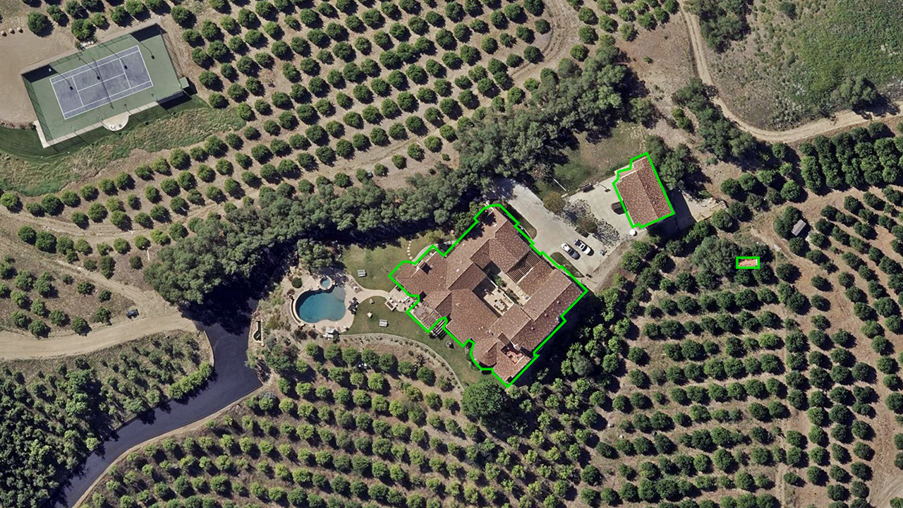
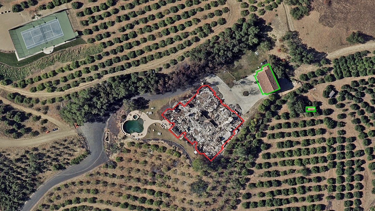
Use before-and-after aerial imagery to assess property damage following disasters such as wildfires, hurricanes, or tornadoes. Vexcel’s Gray Sky imagery helps tax assessors identify destroyed or damaged structures and update property records quickly.
With clear visual evidence, tax assessors can make informed decisions and adjust tax assessments without waiting for field inspections.


Color-infrared (CIR) imagery helps tax assessors evaluate land use by highlighting vegetation and identifying developed areas. Use CIR imagery to distinguish between active farmland, open space, and impervious surfaces like buildings or pavement.
This supports accurate land classification, confirms agricultural use, and informs exemptions or reassessments.
Connect Vexcel imagery and property data with the tools you already use. Access data through the Vexcel Platform (Vexcel APIs, Vexcel Viewer), or partner platforms (like ArcGIS). Use our MapControl SDK to integrate directly into your CAMA system.
Review imagery, property details, and change history in one place. Plus: Our customer advocacy team can help you set it up.
Q: How do tax assessors use aerial imagery from Vexcel?
County assessors and property appraisers use Vexcel’s high-resolution imagery to verify property characteristics, detect change, and support consistent and defensible valuations. This helps maintain accurate tax rolls and reduces the need for field verification.
Q: What property features can I verify with Vexcel imagery?
A: Vexcel imagery reveals critical parcel data such as building footprints, additions, garages, patios, decks, pools, and sheds. Oblique views provide side angles not visible in traditional top-down or street-level images, helping the assessor’s office validate what’s on the ground.
Q: Can I detect property changes using Vexcel imagery?
A: Yes. Compare current and historical imagery to identify change over time, or use AI-derived property attributes to flag new structures or modifications. This supports tax roll maintenance, especially during the reappraisal cycle.
Q: How accurate is the imagery for measurement or verification?
A: Vexcel imagery is matched against ground control points and collected using strict specifications. It meets ASPRS accuracy standards. Assessors and tax appraisers use it to estimate square footage, verify improvements, and support valuation accuracy, all without requiring a site visit.
Q: Does Vexcel cover rural townships and agricultural parcels?
A: Yes. Vexcel captures high-resolution imagery in both urban and rural areas, covering over 3,000 counties and 99.6% of the U.S. population. This includes farmland, small towns, and agricultural zones commonly included in land use classification reviews.
Q: How frequently is the imagery updated for assessment purposes?
A: Urban areas in the U.S. are collected at 7.5 cm resolution and refreshed up to three times per year. Vexcel’s Wide Area program, which collects at 15 cm (6″) resolution, prioritizes cities and rural communities based on population and building density. Rural towns are refreshed more frequently than remote areas like deserts or public lands. Contact us to view our existing imagery library and see refresh details for your specific area.
Q: Can I integrate Vexcel imagery into my assessment tools or CAMA system?
Yes. Vexcel imagery integrates seamlessly into CAMA systems and GIS platforms using APIs, image services, or SDKs. The assessor’s office can access imagery directly within its current workflow and support efficient analysis. We also work with a number of partners.