Vexcel Data Program
  • Home
  • Products
    • Overview
    • Oblique
    • Ortho
    • 3D Cities
    • Elements
    • Elevate
    • Gray Sky
    • Multispectral
    • On Demand
  • Industries
    • Overview
    • Government
      • Property Assessment
      • Public Safety
      • Urban Planning
      • Public Works
    • Telecom
    • Utilities
    • Insurance
      • Underwriting
      • Claims
      • SIU
    • Financial Services
    • Energy
    • AEC
    • HD Maps
    • Smart Cities
  • Coverage
    • All Countries
    • United States
    • Australia
    • Germany
    • Japan
    • United Kingdom
  • Technology
    • Overview
    • Platform
      • Image Services for ArcGIS
      • MapControl SDK
      • Evaluations
    • Partners
    • Viewer
  • Stories
  • About
  • Login
  • Get a Demo
  • Menu Menu

High-Accuracy Geospatial Data for HD Maps

The future of autonomous vehicles and self-driving cars demands accurate location data to develop high-definition maps. Elevate your navigation with rich high-res geospatial from Vexcel.

How HERE Technologies uses Vexcel data

“By extracting upwards of 390 different map attributes (POIs, landmarks, traffic furniture, etc.) from Vexcel’s aerial data mosaics, HERE continues to make advancements in mapmaking and automation to keep the industry’s leading HERE platform fresh.”

Read More

Elevated Road Intelligence

Vexcel’s market-leading cameras collect millions of images every year and each pixel unveils insightful data for AI and ML to identify and index all types of objects for HD Maps. Use Vexcel’s 2D and 3D imagery to classify countless features for precise HD mapping, from parking spots and painted lines to street furniture and pedestrian crossings.


Identify objects with high-res imagery

1
2
3
4
5
1

Bike Lane

2

Stop Light Signal

3

Turn Lanes

4

Parking Lot

5

Railroad

1
2
3
4
5
6
1

Lot Entrance

2

Parking

3

RailRoad Crossing

4

Parking Lot Entrance

5

Parking Spots

6

Overpass

Navigate the Last Mile

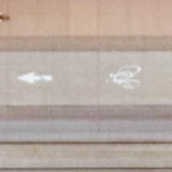
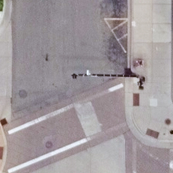
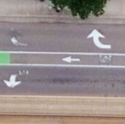
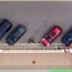
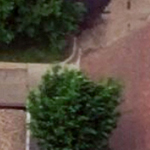
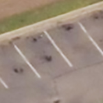
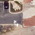
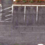
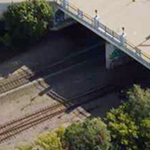
Use high-resolution imagery to bridge the information gap between well-known areas on a map (such as streets) and blank spots (parking lots). Quickly identify key attributes not collected by street view or car-based capture programs by using reliable, consistent aerial data.


Identify objects with high-res imagery

Comprehensive Aerial Data at Scale

See beyond a city block or suburban neighborhood by accessing cloud-based aerial imagery at scale. With both urban and rural capture programs, mapping companies can leverage imagery and geospatial data from coast to coast. Vexcel’s location data products are matched against ground survey points, resulting in the highest caliber of accuracy in imagery. It’s data you can trust.

Related Imagery Products

Obliques

View property from all four cardinal directions in ultra-high-resolution.

Discover More

TrueOrtho

Get a top-down view in high-resolution at scale.

Discover More

See What’s Possible

Looking to take the next step with our world class aerial imagery, elevation & 3D models, or AI-derived property and roadway analytics?

Connect with our team of experts and discuss how Vexcel can take your geospatial imagery and data to the next level.

Request a Demo

Take Vexcel for a spin. Get access to select aerial imagery and data around the world to see our superior coverage and quality for yourself.

Get a 90-Day Evaluation

Products

Oblique
Ortho
3D Cities
Elements
Elevate
Gray Sky
Multispectral
On Demand

Coverage 
Countries

Industries

Government
Telecom
Utilities
Insurance
Financial Services
Energy
AEC
HD Maps
Smart Cities

Technology

Overview
Platform
Partners
Viewer

About
Stories
Videos
Careers
Help Center

Follow Us


Global Leaders in Aerial Imaging.

Vexcel provides industry-leading camera sensors, a dedicated fleet of fixed-wing aircraft, and the largest, most accurate aerial imagery and geospatial data program on the planet.

 width=

Large-format UltraCam cameras & sensors.
vexcel-imaging.com

Aerial surveys by fixed-wing aircraft.
kasurveys.com

Aerial imagery and data for government and business.
vexceldata.com

© Vexcel Imaging US, Inc.
  • Privacy Policy
  • Terms of Use
  • EULA
  • Worldwide
  • AU/NZ
Scroll to top

This site uses cookies. By continuing to browse the site, you are agreeing to our use of cookies.

Accept settingsHide notification onlySettings

Cookie and Privacy Settings


How we use cookies

We may request cookies to be set on your device. We use cookies to let us know when you visit our websites, how you interact with us, to enrich your user experience, and to customize your relationship with our website.

Click on the different category headings to find out more. You can also change some of your preferences. Note that blocking some types of cookies may impact your experience on our websites and the services we are able to offer.

Essential Website Cookies

These cookies are strictly necessary to provide you with services available through our website and to use some of its features.

Because these cookies are strictly necessary to deliver the website, refusing them will have impact how our site functions. You always can block or delete cookies by changing your browser settings and force blocking all cookies on this website. But this will always prompt you to accept/refuse cookies when revisiting our site.

We fully respect if you want to refuse cookies but to avoid asking you again and again kindly allow us to store a cookie for that. You are free to opt out any time or opt in for other cookies to get a better experience. If you refuse cookies we will remove all set cookies in our domain.

We provide you with a list of stored cookies on your computer in our domain so you can check what we stored. Due to security reasons we are not able to show or modify cookies from other domains. You can check these in your browser security settings.

Google Analytics Cookies

These cookies collect information that is used either in aggregate form to help us understand how our website is being used or how effective our marketing campaigns are, or to help us customize our website and application for you in order to enhance your experience.

If you do not want that we track your visit to our site you can disable tracking in your browser here:

Other external services

We also use different external services like Google Webfonts, Google Maps, and external Video providers. Since these providers may collect personal data like your IP address we allow you to block them here. Please be aware that this might heavily reduce the functionality and appearance of our site. Changes will take effect once you reload the page.

Google Webfont Settings:

Google Map Settings:

Google reCaptcha Settings:

Vimeo and Youtube video embeds:

Other cookies

The following cookies are also needed - You can choose if you want to allow them:

Privacy Policy

You can read about our cookies and privacy settings in detail on our Privacy Policy Page.

Accept settingsHide notification only


Gray Sky: Camp House Fire, MN
Read More
This is default text for notification bar
Learn more