
 https://vexceldata.com/wp-content/uploads/2021/12/VEXCEL-Data-Program.png
0
0
kris.wagner
https://vexceldata.com/wp-content/uploads/2021/12/VEXCEL-Data-Program.png
kris.wagner2018-02-06 10:28:272024-10-08 08:39:15Florida Windstorm – Winter Storm Liam
https://vexceldata.com/wp-content/uploads/2018/01/Screen-Shot-2018-01-15-at-18.10.33.png
820
1752
kris.wagner
https://vexceldata.com/wp-content/uploads/2021/12/VEXCEL-Data-Program.png
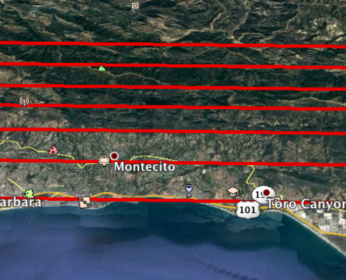
kris.wagner2018-01-15 10:13:512024-10-08 08:39:15CA Mudslide Area of Interest (AOI)
https://vexceldata.com/wp-content/uploads/2021/12/VEXCEL-Data-Program.png
0
0
kris.wagner
https://vexceldata.com/wp-content/uploads/2021/12/VEXCEL-Data-Program.png
kris.wagner2018-01-12 19:19:172024-10-08 08:39:16CA Mudslide Imagery coming shortly
https://vexceldata.com/wp-content/uploads/2021/12/VEXCEL-Data-Program.png
0
0
kris.wagner
https://vexceldata.com/wp-content/uploads/2021/12/VEXCEL-Data-Program.png
kris.wagner2017-12-26 16:34:282024-10-08 08:39:16Thomas Wildfire imagery round 2 is online
https://vexceldata.com/wp-content/uploads/2021/12/VEXCEL-Data-Program.png
0
0
kris.wagner
https://vexceldata.com/wp-content/uploads/2021/12/VEXCEL-Data-Program.png
kris.wagner2017-12-19 16:53:482024-10-08 08:39:16Ventura, CA wildfires scheduled for re-flight Dec 20th
https://vexceldata.com/wp-content/uploads/2021/12/VEXCEL-Data-Program.png
0
0
kris.wagner
https://vexceldata.com/wp-content/uploads/2021/12/VEXCEL-Data-Program.png
kris.wagner2017-12-17 17:24:572024-10-08 08:39:17Update on Ventura, CA wildfires collection plan
https://vexceldata.com/wp-content/uploads/2021/12/VEXCEL-Data-Program.png
0
0
kris.wagner
https://vexceldata.com/wp-content/uploads/2021/12/VEXCEL-Data-Program.png
kris.wagner2017-12-17 13:47:532024-10-08 08:39:17Ventura, CA Fire Imagery Flown and Deployed to Map App
https://vexceldata.com/wp-content/uploads/2021/12/VEXCEL-Data-Program.png
0
0
kris.wagner
https://vexceldata.com/wp-content/uploads/2021/12/VEXCEL-Data-Program.png
kris.wagner2017-12-12 17:44:572024-10-08 08:39:17Ventura, CA wildfires planned for re-flight December 13th
https://vexceldata.com/wp-content/uploads/2021/12/VEXCEL-Data-Program.png
0
0
kris.wagner
https://vexceldata.com/wp-content/uploads/2021/12/VEXCEL-Data-Program.png
kris.wagner2017-12-11 17:42:372024-10-08 08:39:18Ventura, CA update – conditions remain poor
https://vexceldata.com/wp-content/uploads/2021/12/VEXCEL-Data-Program.png
0
0
kris.wagner
https://vexceldata.com/wp-content/uploads/2021/12/VEXCEL-Data-Program.png
kris.wagner2018-02-06 10:28:272024-10-08 08:39:15Florida Windstorm – Winter Storm Liam
https://vexceldata.com/wp-content/uploads/2018/01/Screen-Shot-2018-01-15-at-18.10.33.png
820
1752
kris.wagner
https://vexceldata.com/wp-content/uploads/2021/12/VEXCEL-Data-Program.png
kris.wagner2018-01-15 10:13:512024-10-08 08:39:15CA Mudslide Area of Interest (AOI)
https://vexceldata.com/wp-content/uploads/2021/12/VEXCEL-Data-Program.png
0
0
kris.wagner
https://vexceldata.com/wp-content/uploads/2021/12/VEXCEL-Data-Program.png
kris.wagner2018-01-12 19:19:172024-10-08 08:39:16CA Mudslide Imagery coming shortly
https://vexceldata.com/wp-content/uploads/2021/12/VEXCEL-Data-Program.png
0
0
kris.wagner
https://vexceldata.com/wp-content/uploads/2021/12/VEXCEL-Data-Program.png
kris.wagner2017-12-26 16:34:282024-10-08 08:39:16Thomas Wildfire imagery round 2 is online
https://vexceldata.com/wp-content/uploads/2021/12/VEXCEL-Data-Program.png
0
0
kris.wagner
https://vexceldata.com/wp-content/uploads/2021/12/VEXCEL-Data-Program.png
kris.wagner2017-12-19 16:53:482024-10-08 08:39:16Ventura, CA wildfires scheduled for re-flight Dec 20th
https://vexceldata.com/wp-content/uploads/2021/12/VEXCEL-Data-Program.png
0
0
kris.wagner
https://vexceldata.com/wp-content/uploads/2021/12/VEXCEL-Data-Program.png
kris.wagner2017-12-17 17:24:572024-10-08 08:39:17Update on Ventura, CA wildfires collection plan
https://vexceldata.com/wp-content/uploads/2021/12/VEXCEL-Data-Program.png
0
0
kris.wagner
https://vexceldata.com/wp-content/uploads/2021/12/VEXCEL-Data-Program.png
kris.wagner2017-12-17 13:47:532024-10-08 08:39:17Ventura, CA Fire Imagery Flown and Deployed to Map App
https://vexceldata.com/wp-content/uploads/2021/12/VEXCEL-Data-Program.png
0
0
kris.wagner
https://vexceldata.com/wp-content/uploads/2021/12/VEXCEL-Data-Program.png
kris.wagner2017-12-12 17:44:572024-10-08 08:39:17Ventura, CA wildfires planned for re-flight December 13th
https://vexceldata.com/wp-content/uploads/2021/12/VEXCEL-Data-Program.png
0
0
kris.wagner
https://vexceldata.com/wp-content/uploads/2021/12/VEXCEL-Data-Program.png
kris.wagner2017-12-11 17:42:372024-10-08 08:39:18Ventura, CA update – conditions remain poor