
Hurricane Season is Officially Here–What’s in Your Toolkit for Response?

Damage from Hurricane Helene
The Atlantic hurricane season is right around the corner, starting June 1 and running through November 30, 2025. The National Oceanic and Atmospheric Association (NOAA) predicts a 60% chance of an above-normal hurricane season for this year*. For six months, weather forecasters will keep a close eye on impending storms and for six months, insurers, government agencies, and more will wait and watch, getting ready to respond.
Given the increasing frequency and intensity of storms, now is the time to prepare and build your own hurricane response toolkit with one of the best assets available: aerial imagery.
The Role of Aerial Imagery in Hurricane Response
Once a massive storm moves through an area, the first thing everyone wants to know is: what does it look like now? What really happened? What’s left standing? How bad is the damage?
High-resolution aerial imagery has become an indispensable tool for assessing damage and coordinating emergency responses. Aerial imagery enables insurers and emergency responders to:
- Assess Damage Accurately: Identify the extent of destruction to properties and infrastructure.
- Prioritize Response Efforts: Determine which areas require immediate attention.
- Facilitate Insurance Claims: Provide visual evidence to support claims.
Vexcel’s Gray Sky program captures high-resolution aerial imagery following major disasters like hurricanes, wildfires, and tornadoes, and delivers it to the cloud and other popular GIS platforms as soon as possible.
Vexcel also has a robust library of historical imagery so you can quickly view and compare pre- and post-disaster images.
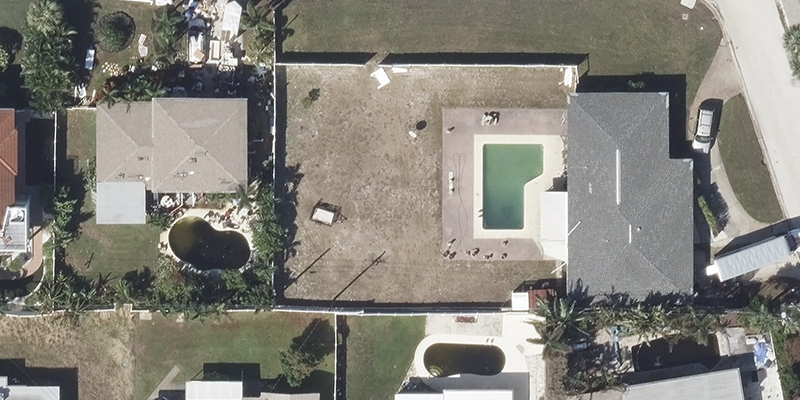
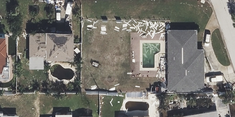
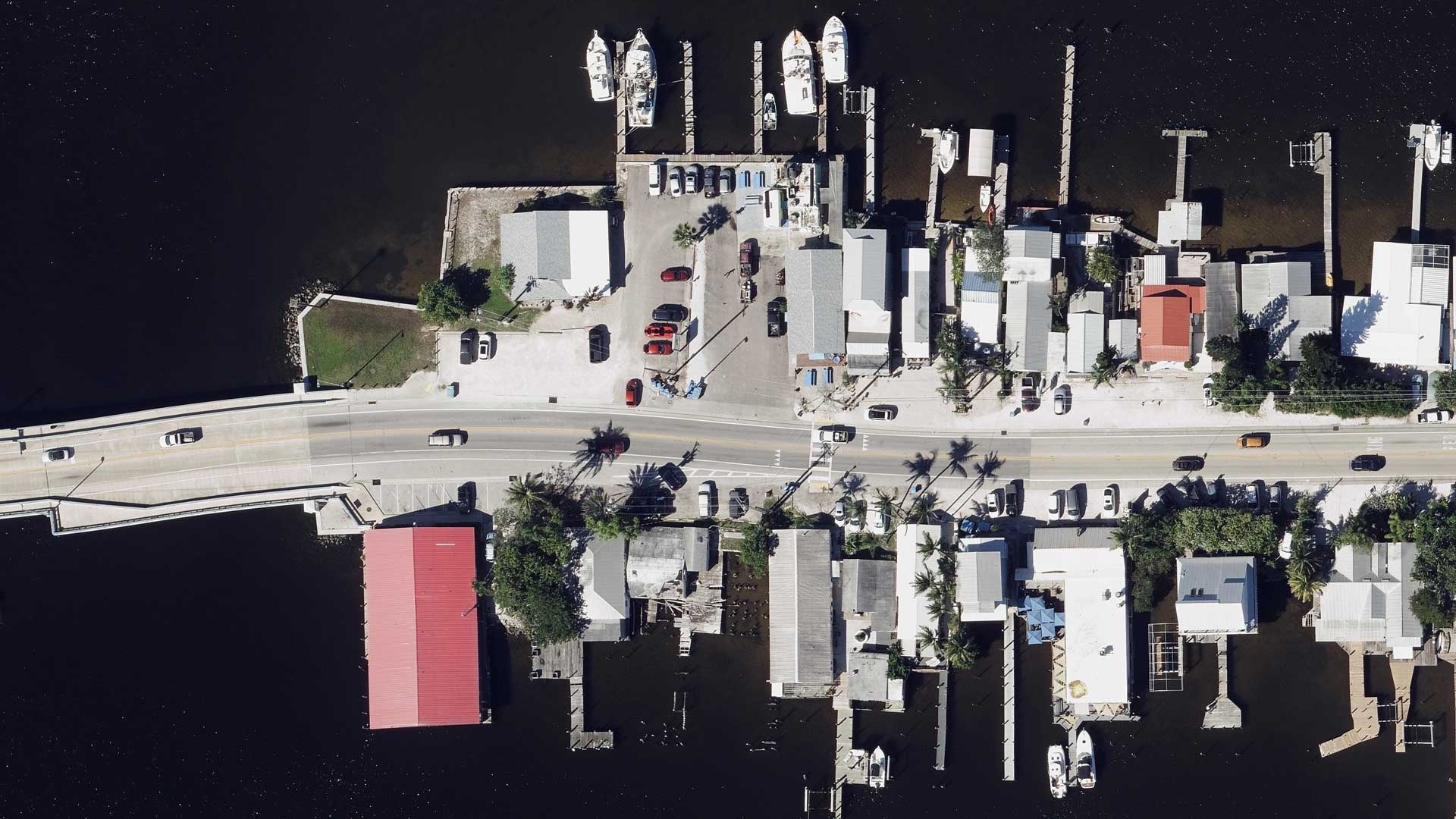
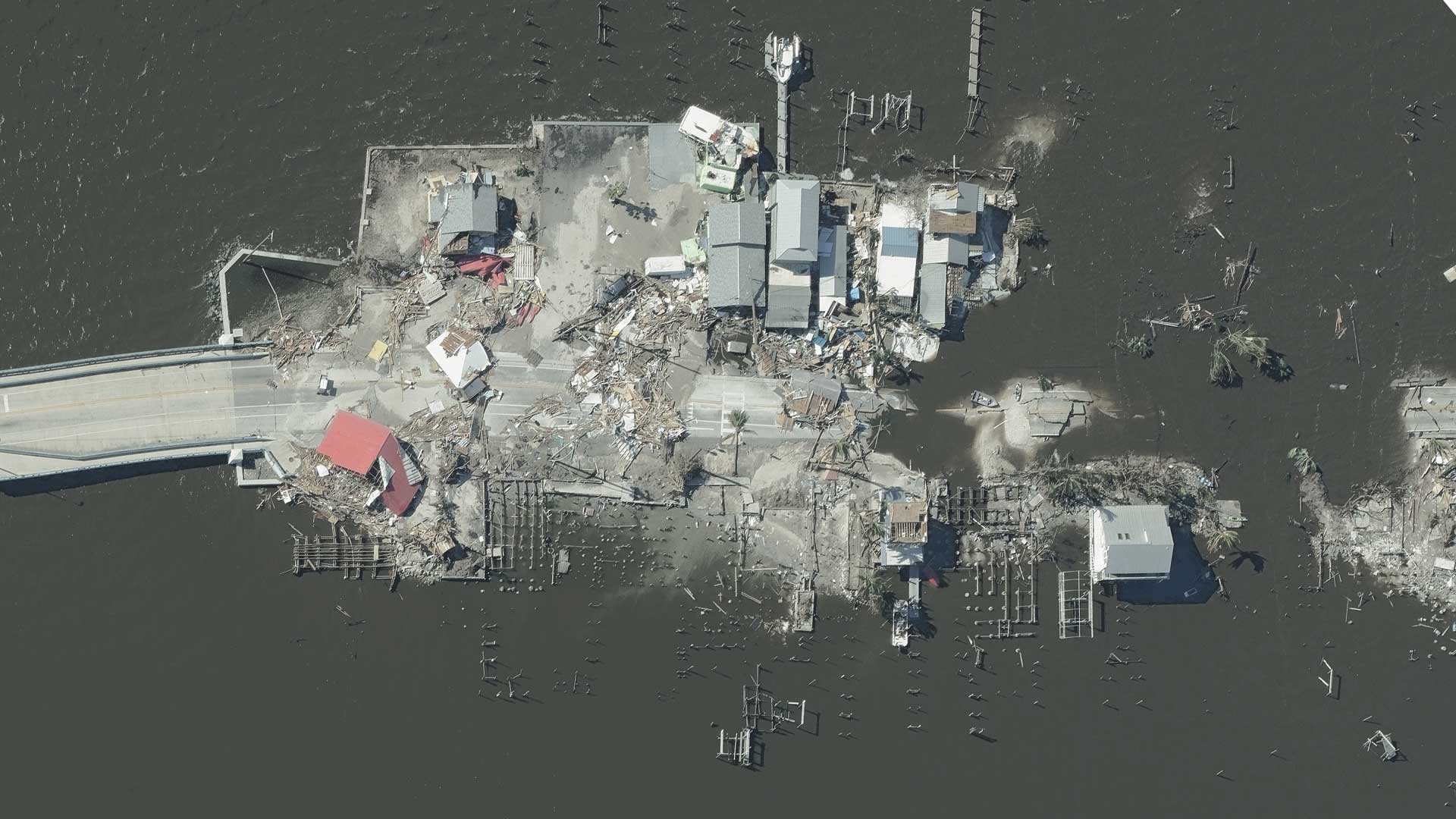
Below are examples of before/after imagery from Hurricane Milton and Hurricane Ian.
AI Insights for Analysis on Damaged Properties
Once imagery is collected, AI is applied to the imagery and delivers information back on the level of damage. There are two critical ways this helps our customers:
- First, it allows them at a macro level to home in on the most damaged areas without the need to sift and search through massive amounts of data.
- Second, it provides damage assessment information on a property to indicate the degree to which it has been damaged or destroyed.
These two pieces of information speed up response times so that an insurer can proactively reach out to a customer and already know what’s happened to their property and emergency agencies can see in seconds the hardest hits areas after a storm.
Last year, we collected nearly 20% of Florida following Hurricane Milton and analyzed over 4.43 million structures for damage. Below is an example of a macro view of damage footprints following Hurricane Milton as well as a full Damage Assessment on a property.

Damage footprints from Hurricane Milton

Damage Assessment for property impacted by Hurricane Milton
Following the Rebuilding of Communities
Access to Vexcel’s Gray Sky imagery helps you see for that moment in time what happened for a particular disaster. But what about what’s happened months after? How are communities rebuilding? What does that look like?
Vexcel is continuously collecting imagery across the contiguous U.S. in both urban and rural areas. Due to this ongoing collection, many of the areas that have been hit hard by hurricanes in the past have been captured again, enabling the ability to check any restoration or rebuilding that might be happening.
Not only is this information encouraging to see for restoring communities back to their functional state, but it can also highlight how a community is being rebuilt. If homes were destroyed, are they being rebuilt the same way, with the same material, in the same spot? Or are areas still in the long process of restoration or property owners choosing not to rebuild?

Before/After/After images showing rebuild of a home. Roof material and shape changed in rebuild.

Before/After showing rebuild of a home following a hurricane. Footprint has been expanded and roof type has changed.
Be Prepared, Get Hurricane Ready with Vexcel Imagery
With no way of knowing just how intense and damaging this hurricane season could be, the only sure thing to count on is knowing you can have access to imagery and data following a major event. To get access to all that Vexcel has to offer, connect with our team so you feel more prepared heading into the 2025 hurricane season.
* https://www.noaa.gov/news-release/noaa-predicts-above-normal-2025-atlantic-hurricane-season

