 https://vexceldata.com/wp-content/uploads/2023/02/US-OK-Norman-Tornado-4.jpg
682
1211
kris.wagner
https://vexceldata.com/wp-content/uploads/2021/12/VEXCEL-Data-Program.png
kris.wagner2023-02-28 09:17:512026-04-14 15:57:56Gray Sky: Tornado in Norman, Oklahoma
https://vexceldata.com/wp-content/uploads/2023/02/US-OK-Norman-Tornado-4.jpg
682
1211
kris.wagner
https://vexceldata.com/wp-content/uploads/2021/12/VEXCEL-Data-Program.png
kris.wagner2023-02-28 09:17:512026-04-14 15:57:56Gray Sky: Tornado in Norman, Oklahoma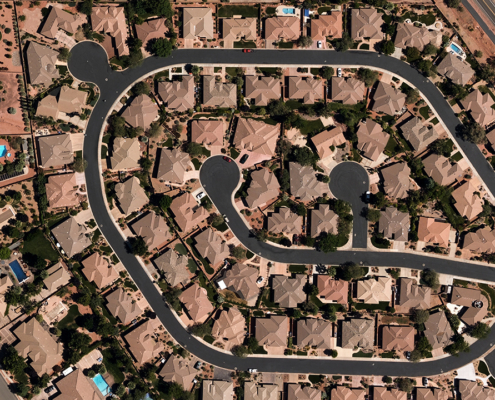 https://vexceldata.com/wp-content/uploads/2022/11/St.-George.jpg
720
1280
vexcel
https://vexceldata.com/wp-content/uploads/2021/12/VEXCEL-Data-Program.png
vexcel2023-02-23 20:37:592024-09-24 10:51:11U.S. Collection Expanding in 2023
https://vexceldata.com/wp-content/uploads/2022/11/St.-George.jpg
720
1280
vexcel
https://vexceldata.com/wp-content/uploads/2021/12/VEXCEL-Data-Program.png
vexcel2023-02-23 20:37:592024-09-24 10:51:11U.S. Collection Expanding in 2023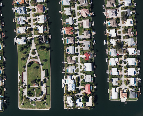 https://vexceldata.com/wp-content/uploads/2022/01/12-Starfish-Dr-Vero-Beach-FL-32960-USA.jpg
576
1024
vexcel
https://vexceldata.com/wp-content/uploads/2021/12/VEXCEL-Data-Program.png
vexcel2023-02-13 18:58:202026-04-14 15:47:02BIG News: Vexcel Enhancing & Refreshing U.S. Collection Program in 2023
https://vexceldata.com/wp-content/uploads/2022/01/12-Starfish-Dr-Vero-Beach-FL-32960-USA.jpg
576
1024
vexcel
https://vexceldata.com/wp-content/uploads/2021/12/VEXCEL-Data-Program.png
vexcel2023-02-13 18:58:202026-04-14 15:47:02BIG News: Vexcel Enhancing & Refreshing U.S. Collection Program in 2023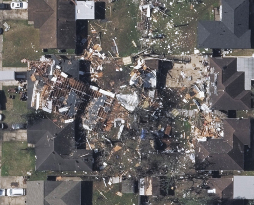 https://vexceldata.com/wp-content/uploads/2023/01/US-TX-Houston-Tornado-7.jpg
772
1374
vexcel
https://vexceldata.com/wp-content/uploads/2021/12/VEXCEL-Data-Program.png
vexcel2023-01-26 14:26:492026-04-14 15:57:56Gray Sky Event: Tornado Hits Metro Areas in Houston, Texas
https://vexceldata.com/wp-content/uploads/2023/01/US-TX-Houston-Tornado-7.jpg
772
1374
vexcel
https://vexceldata.com/wp-content/uploads/2021/12/VEXCEL-Data-Program.png
vexcel2023-01-26 14:26:492026-04-14 15:57:56Gray Sky Event: Tornado Hits Metro Areas in Houston, Texas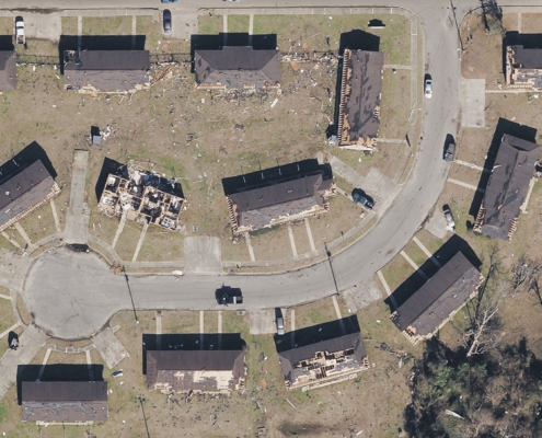 https://vexceldata.com/wp-content/uploads/2023/01/US-AL-Selma-Tornado-3.jpg
1097
1951
vexcel
https://vexceldata.com/wp-content/uploads/2021/12/VEXCEL-Data-Program.png
vexcel2023-01-15 10:50:512026-04-14 15:57:59Gray Sky Event: Southeast Tornadoes
https://vexceldata.com/wp-content/uploads/2023/01/US-AL-Selma-Tornado-3.jpg
1097
1951
vexcel
https://vexceldata.com/wp-content/uploads/2021/12/VEXCEL-Data-Program.png
vexcel2023-01-15 10:50:512026-04-14 15:57:59Gray Sky Event: Southeast Tornadoes https://vexceldata.com/wp-content/uploads/2023/01/AU-SA-MurrayBridge-Flooding-5.jpg
1010
1795
vexcel
https://vexceldata.com/wp-content/uploads/2021/12/VEXCEL-Data-Program.png
vexcel2023-01-13 12:46:022024-09-24 10:56:07Gray Sky Event: Australia Floods
https://vexceldata.com/wp-content/uploads/2023/01/AU-SA-MurrayBridge-Flooding-5.jpg
1010
1795
vexcel
https://vexceldata.com/wp-content/uploads/2021/12/VEXCEL-Data-Program.png
vexcel2023-01-13 12:46:022024-09-24 10:56:07Gray Sky Event: Australia Floods https://vexceldata.com/wp-content/uploads/2022/12/Instagram_1080x1080_V2.png
1080
1080
vexcel
https://vexceldata.com/wp-content/uploads/2021/12/VEXCEL-Data-Program.png
vexcel2022-12-27 22:23:122026-04-14 15:49:292022 was our BIGGEST year yet: Big Data, New Products, More Countries
https://vexceldata.com/wp-content/uploads/2022/12/Instagram_1080x1080_V2.png
1080
1080
vexcel
https://vexceldata.com/wp-content/uploads/2021/12/VEXCEL-Data-Program.png
vexcel2022-12-27 22:23:122026-04-14 15:49:292022 was our BIGGEST year yet: Big Data, New Products, More Countries https://vexceldata.com/wp-content/uploads/2022/12/Instagram_1080x1080_V2-1.png
1080
1080
vexcel
https://vexceldata.com/wp-content/uploads/2021/12/VEXCEL-Data-Program.png
vexcel2022-12-27 16:31:372026-04-14 15:49:342022: A Transformational Year—More Members, More Images, and More Property Insights
https://vexceldata.com/wp-content/uploads/2022/12/Instagram_1080x1080_V2-1.png
1080
1080
vexcel
https://vexceldata.com/wp-content/uploads/2021/12/VEXCEL-Data-Program.png
vexcel2022-12-27 16:31:372026-04-14 15:49:342022: A Transformational Year—More Members, More Images, and More Property Insights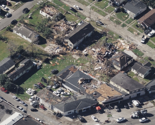 https://vexceldata.com/wp-content/uploads/2022/12/US-LA-NewOrleans-Tornado-1-W.jpg
1014
1803
vexcel
https://vexceldata.com/wp-content/uploads/2021/12/VEXCEL-Data-Program.png
vexcel2022-12-16 11:25:532026-04-14 15:58:00Gray Sky Event: New Orleans Tornado
https://vexceldata.com/wp-content/uploads/2022/12/US-LA-NewOrleans-Tornado-1-W.jpg
1014
1803
vexcel
https://vexceldata.com/wp-content/uploads/2021/12/VEXCEL-Data-Program.png
vexcel2022-12-16 11:25:532026-04-14 15:58:00Gray Sky Event: New Orleans Tornado
