Vexcel Platform
Build apps, power AI, and add Vexcel imagery and data where you need it.


Build apps, power AI, and add Vexcel imagery and data where you need it.
Access Vexcel data your way. Our platform supports a wide range of use cases, from apps and AI to integrations and custom workflows. Use APIs, SDKs, and services to bring high-resolution imagery and geospatial data into your systems. Explore imagery in the web-based Vexcel Viewer. Or, deploy datasets on-premises for secure, offline use.
Use Vexcel APIs to stream imagery and datasets directly into your applications. Access tiles, extracts, and collections across 2D, 3D, elevation data, and more.


Explore high-resolution aerial imagery with tools to measure distance, area, and more. View ortho and oblique imagery from multiple collections, compare side by side, and analyze up to 40+ attributes per property.
Connect your AI apps to Vexcel aerial imagery and geospatial data with Vexcel MCP (Model Context Protocol). Query the real world, uncover patterns, and find answers faster.


Save months in development time and launch faster with MapControl SDK.
With just few lines of JavaScript code, developers can build Vexcel imagery and other tools into their mobile and web applications as well as GIS, CAMA and CAD programs.
Access orthomosaic imagery, oblique and nadir imagery, and elevation data in Esri apps and software.
With Image Services for ArcGIS, you get new imagery and data updates as we publish it. No plug-ins required.

 https://vexceldata.com/wp-content/uploads/2025/07/33.476080-117.62631-SanClementeCA.jpg
579
1024
vexcel
https://vexceldata.com/wp-content/uploads/2021/12/VEXCEL-Data-Program.png
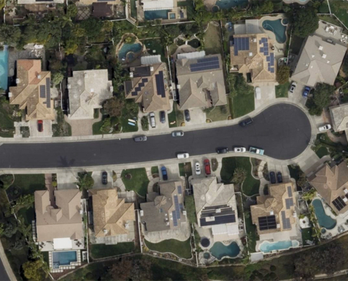
vexcel2025-07-23 09:24:492026-04-14 15:54:12Top 3 Ways Vexcel API 2.0 Delivers Powerful AI Insights on Properties
https://vexceldata.com/wp-content/uploads/2025/07/33.476080-117.62631-SanClementeCA.jpg
579
1024
vexcel
https://vexceldata.com/wp-content/uploads/2021/12/VEXCEL-Data-Program.png
vexcel2025-07-23 09:24:492026-04-14 15:54:12Top 3 Ways Vexcel API 2.0 Delivers Powerful AI Insights on Properties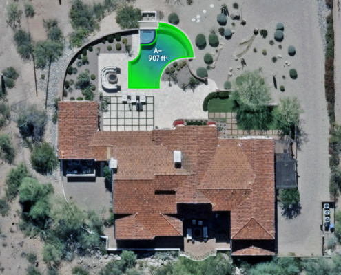 https://vexceldata.com/wp-content/uploads/2025/07/4743-N-54th-St-Phoenix-AZ-85018-USA_polygon.jpg
720
1280
vexcel
https://vexceldata.com/wp-content/uploads/2021/12/VEXCEL-Data-Program.png
vexcel2025-07-16 08:00:442026-04-14 15:54:14How Many Pools are in Phoenix? Elements AI Gave Us the Answer
https://vexceldata.com/wp-content/uploads/2025/07/4743-N-54th-St-Phoenix-AZ-85018-USA_polygon.jpg
720
1280
vexcel
https://vexceldata.com/wp-content/uploads/2021/12/VEXCEL-Data-Program.png
vexcel2025-07-16 08:00:442026-04-14 15:54:14How Many Pools are in Phoenix? Elements AI Gave Us the Answer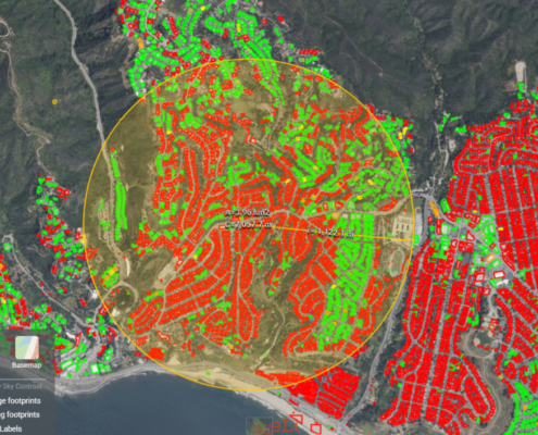 https://vexceldata.com/wp-content/uploads/2025/01/Wildfire-Location-LA.jpg
706
960
vexcel
https://vexceldata.com/wp-content/uploads/2021/12/VEXCEL-Data-Program.png
vexcel2025-01-22 13:49:122026-04-14 15:54:14Wildfire Damage Extraction with API 2.0
https://vexceldata.com/wp-content/uploads/2025/01/Wildfire-Location-LA.jpg
706
960
vexcel
https://vexceldata.com/wp-content/uploads/2021/12/VEXCEL-Data-Program.png
vexcel2025-01-22 13:49:122026-04-14 15:54:14Wildfire Damage Extraction with API 2.0![]()
Large-format UltraCam cameras & sensors.
vexcel-imaging.com
Aerial surveys by fixed-wing aircraft.
kasurveys.com
Aerial imagery and data for government and business.
vexceldata.com