Gray Sky: California Wildfires
High-resolution imagery and damage assessments for Palisades and Eaton Fires available including surrounding fires.


Tuesday, Feb. 4, 2025
Another Round of Imagery Published
With the LA fires nearly or fully contained, our flight team collected another round of Gray Sky imagery on Sunday, Feb. 2, covering the Palisades, Hurst, Sunset, and Eaton areas. This ortho imagery is now available on the Vexcel Platform and select partner sites.
This latest 10cm high-resolution imagery offers additional views of the fire’s impact, helping communities, emergency managers, and insurers assess the full extent of the damage. These detailed insights are critical for guiding recovery efforts, informing claims, and supporting the rebuilding process for affected residents and businesses. Please reach out below for more details about all our collections.
__________
Tuesday, Jan. 21, 2025
More Imagery Collected
Our Gray Sky team continues to monitor the Los Angeles fires and is working closely with local emergency managers, customers, and partners.
Yesterday, we deployed an aircraft to collect another round of high-resolution ortho imagery at 10cm resolution, covering the Palisades, Hurst, Sunset, and Eaton fire zones. This new collection provides an updated view of property damage, offering insights into additional growth and the full scope of the impact.
__________
Tuesday Afternoon, Jan. 14, 2025
Update
Imagery from the third and final collection of the Palisades area is published and live. This high-resolution ortho imagery provides additional views of the impacted areas and is another way to validate the damage suffered on the ground. New imagery has also been added to the gallery below. This also marks the completion of our Gray Sky response to the fires in the greater Los Angeles area for the time being. Our Gray Sky team will continue to monitor the event and should anything change, we will activate again.
__________
Monday Afternoon, Jan. 13, 2025
Today’s Collection
Today our Gray Sky team completed a third round of collection over the Palisades fire area and the data is en route to our processing center. High-resolution ortho imagery of the impacted area will be available shortly. This is the final day of collection for the wildfires that have ravaged the greater Los Angeles area. Our Gray Sky team will continue to monitor what happens and will activate again if things drastically change. To date, our planes collected the following:
- Palisades fire: three times
- Eaton fire: two times
- Hurst, Kenneth, Sunset fires: one time
__________
Sunday Afternoon, Jan. 12, 2025
Today’s Update
A second round of aerial imagery is now available with additional captures of the Palisades and Eaton fires and new imagery of the Kenneth, Sunset, and Hurst Fire zones. This imagery is available for customers and partners on the Vexcel Platform and partner sites. The weather prohibited any plans for collection on Sunday with high winds and increasing smoke so the Gray Sky team will continue to monitor and work with emergency managers on when to be back in the air safely to add to the growing collection of imagery of this devastated area.
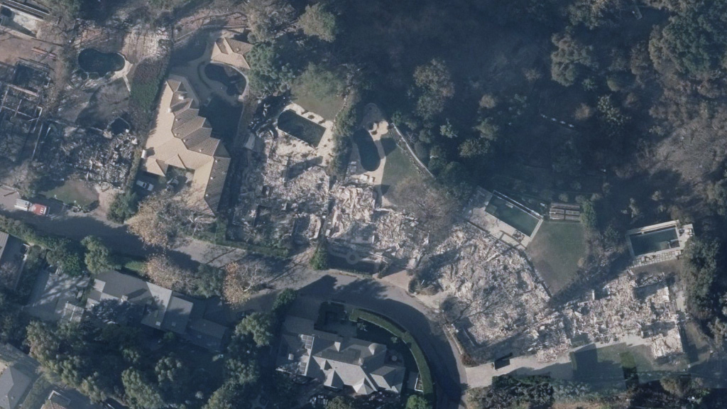
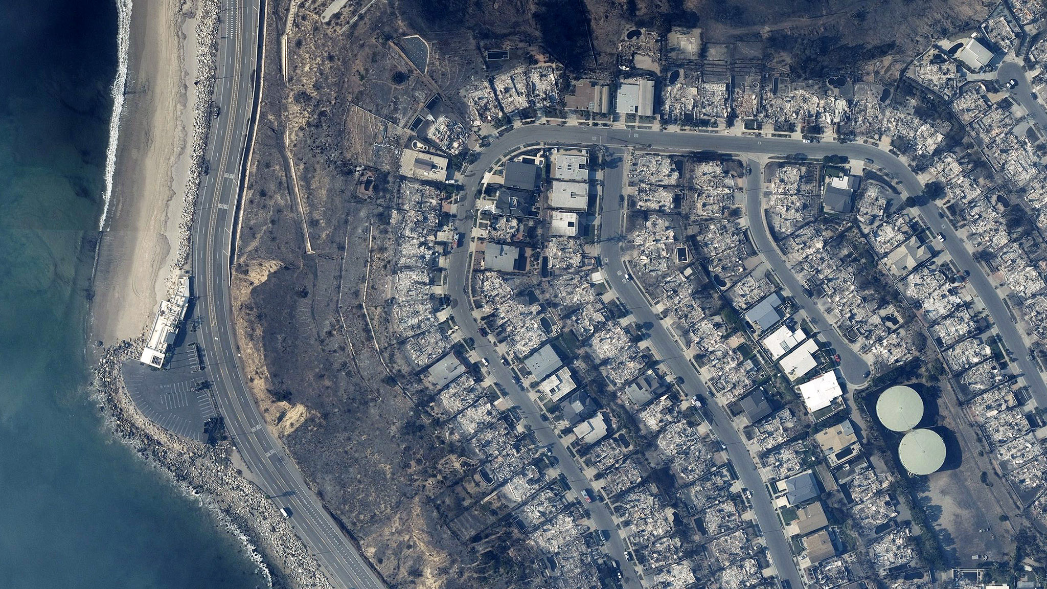
Today’s additional imagery has been added to the gallery below, including a new before/after to highlight the losses suffered by so many.
__________
Saturday Afternoon, Jan. 11, 2025
Today’s Collections
Our flight teams successfully completed a second day of imagery collections, capturing new areas including the Kenneth Fire, Sunset Fire, and Hurst Fire zones. Additionally, we collected a second capture of both the Palisades Fire and Eaton Fire zones. The imagery is now en route to our processing center and will be made available as soon as possible. Color-coded damage footprints and property damage assessments are now available for our initial collections of the Palisades Fire and Eaton Fire.
__________
Saturday Morning, Jan. 11, 2025
Supporting Response Efforts
As wildfires continue to devastate California, our Gray Sky team has been fully activated to capture high-resolution aerial imagery. This imagery is essential for insurance providers, emergency managers, government agencies, utilities, and other critical sectors to assess damage and plan effective response efforts.
Since Tuesday, high winds, thick smoke, and temporary flight restrictions have made aircraft collections challenging. However, winds slowed on Friday, allowing our flight team to successfully capture imagery. More collections are planned throughout the weekend.
Imagery Published
As of early Saturday morning, our team has published high-resolution oblique, ortho, and multispectral imagery, covering approximately 360 square kilometers of wildfire-impacted areas, including the Palisades Fire and Eaton Fire zones. These collections provide detailed views of damaged properties and neighborhoods, offering a comprehensive understanding of the devastating impact of these fires. Imagery is available for customers and partners on the Vexcel Platform and partner sites.


Ongoing Efforts Through the Weekend
The situation on the ground continues to evolve rapidly, including shifting smoke conditions. We are expanding our aircraft operations and collections this weekend to include additional fire zones, such as the Kenneth Fire, Sunset Fire, and Hurst Fire areas.
We are also reflying fire zones if they expand and conducting additional collections as needed. Our team is collaborating with local emergency managers to identify any expanded collection requirements.
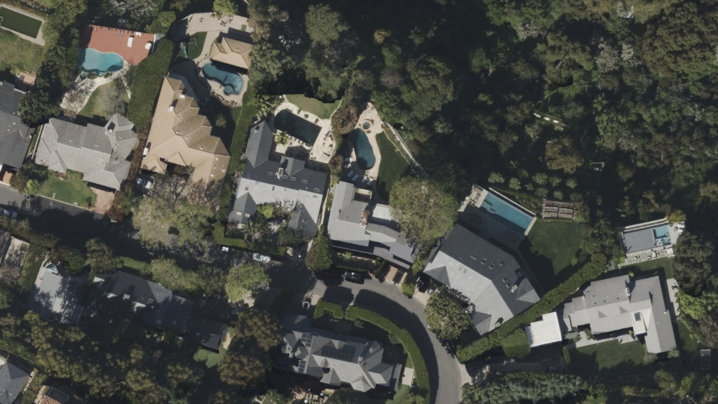
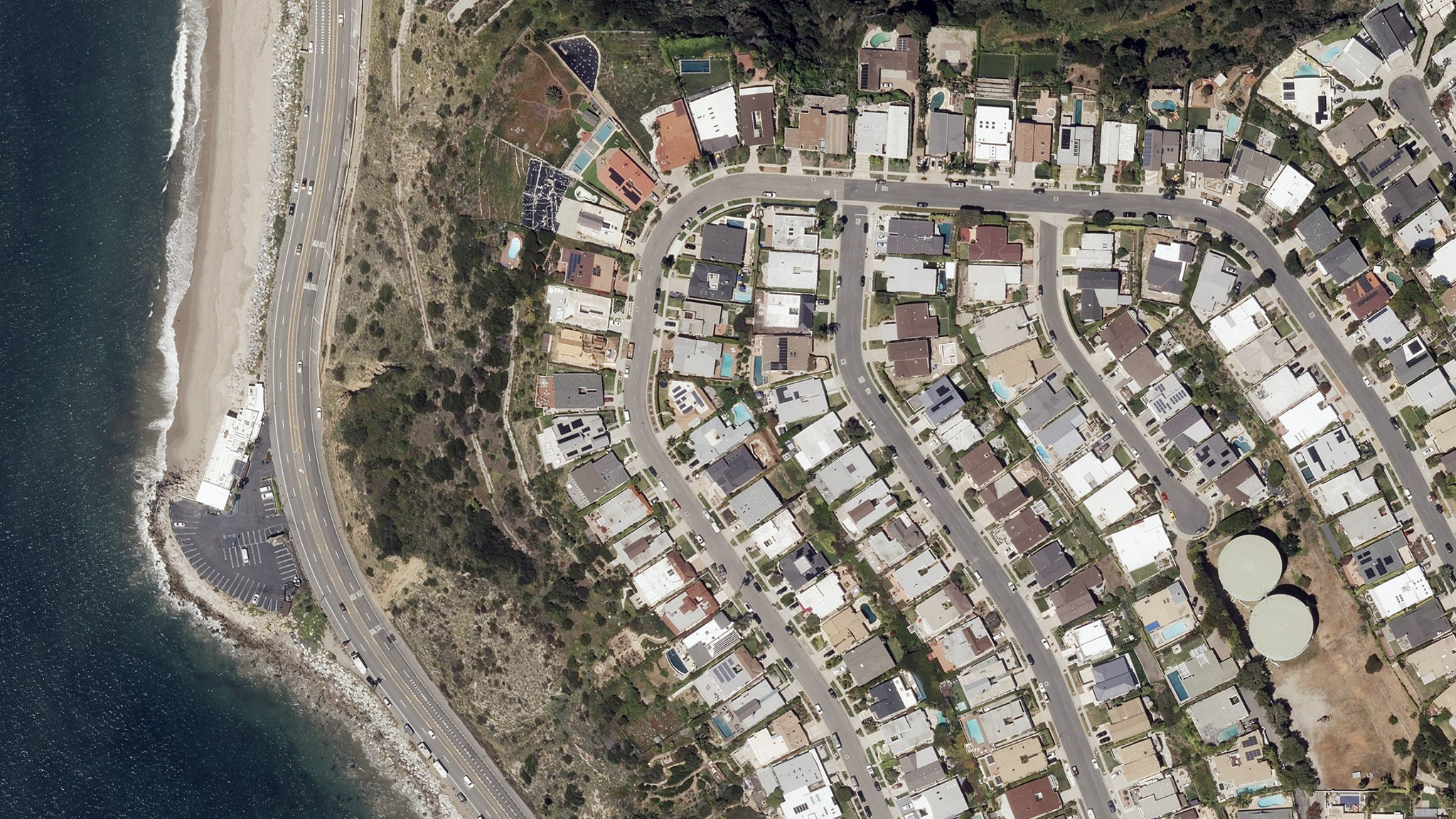
Comparison Imagery & Property Damage Assessments
Vexcel has historical imagery from previous collections in these areas, enabling before-and-after comparisons. Once the wildfire imagery is processed, we will deliver damage assessments for every property within our post-CAT imagery collections to further support recovery and response efforts.