
NEW: Digital Surface Model API Now Available
GET DSM DATA ON DEMAND
No longer do you need to wait for hours on end to download massive GeoTIFF files for your DSM data. Vexcel just launched a new API providing easier—and quicker—access to its 7.5cm resolution Digital Surface Model data.
DSM—Why It’s Useful
Digital Surface Model data helps you understand and better visualize what exists on the earth’s surface. This valuable information is used to extract data to better predict flood modeling, evaluate man-made objects on all types of property, and improve risk analysis and assessments.
What You Get
The new API provides standard 256 x 256 tiles in GeoTIFF format, conforming to WMTS spec requirements so the data aligns perfectly with other types of Vexcel content, including true orthos and near-infrared tiles. This allows you to avoid any painful up/down sampling or need to transform data when matching DSM to Vexcel’s superior imagery.

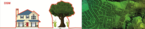
You can see a quick example of how perfectly every pixel is read from the GeoTIFF file below as compared to the ortho.
How to Get Started
To begin accessing DSM data via the API, follow the simple instructions included in the API documentation here. You can quickly render or display data in a variety of platforms whether you’re familiar with DSM data or not. Additional information can also be found here on my technical blog.
As always, if you have any questions or need support for Vexcel products, please don’t hesitate to reach out to our Customer Support team at support@vexcelgroup.com.
Access the on demand DSM webinar
Want to know how to get started using DSM data? Get access to our on demand webinar, featuring information such as:
- What the difference is between DSM and DTM
- How you can start using data immediately for everyday use cases
- How Vexcel’s award-winning tech provides a perfect pixel-to-pixel match between imagery and DSM data
Visit this page to learn more and start discovering how DSM data can help you in your every day workflows!
Steve Lombardi is a long-time geospatial geek and loves all things data and showing off the stunning imagery of Vexcel. He is the Director of Customer Advocacy for Vexcel and helps customers understand how to maximize their usage of VDP data. He is the creator of The Ground Truth blog, offering illustrative use cases and highlights of Vexcel products.

