 https://vexceldata.com/wp-content/uploads/2022/10/310-S-Michigan-Ave-Chicago-IL-60604-USA.jpg
720
1280
vexcel
https://vexceldata.com/wp-content/uploads/2021/12/VEXCEL-Data-Program.png
vexcel2022-10-13 16:24:192026-04-14 15:50:10SkyWatch Names Vexcel as New Partner
https://vexceldata.com/wp-content/uploads/2022/10/310-S-Michigan-Ave-Chicago-IL-60604-USA.jpg
720
1280
vexcel
https://vexceldata.com/wp-content/uploads/2021/12/VEXCEL-Data-Program.png
vexcel2022-10-13 16:24:192026-04-14 15:50:10SkyWatch Names Vexcel as New Partner https://vexceldata.com/wp-content/uploads/2022/10/26.499674-81.967837.jpeg
987
1755
vexcel
https://vexceldata.com/wp-content/uploads/2021/12/VEXCEL-Data-Program.png
vexcel2022-10-09 16:28:572026-04-14 15:50:11Assess Utilities & Infrastructure After Disaster with High-res Aerial Imagery
https://vexceldata.com/wp-content/uploads/2022/10/26.499674-81.967837.jpeg
987
1755
vexcel
https://vexceldata.com/wp-content/uploads/2021/12/VEXCEL-Data-Program.png
vexcel2022-10-09 16:28:572026-04-14 15:50:11Assess Utilities & Infrastructure After Disaster with High-res Aerial Imagery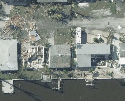 https://vexceldata.com/wp-content/uploads/2022/10/GIC-Aerial-Imagery-5.jpg
1080
1920
vexcel
https://vexceldata.com/wp-content/uploads/2021/12/VEXCEL-Data-Program.png
vexcel2022-10-05 17:03:042026-04-14 15:50:12Capturing Hurricane Ian’s Destructive Path
https://vexceldata.com/wp-content/uploads/2022/10/GIC-Aerial-Imagery-5.jpg
1080
1920
vexcel
https://vexceldata.com/wp-content/uploads/2021/12/VEXCEL-Data-Program.png
vexcel2022-10-05 17:03:042026-04-14 15:50:12Capturing Hurricane Ian’s Destructive Path
