 https://vexceldata.com/wp-content/uploads/2022/10/26.499674-81.967837.jpeg
987
1755
vexcel
https://vexceldata.com/wp-content/uploads/2021/12/VEXCEL-Data-Program.png
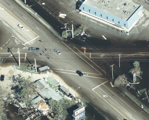
vexcel2022-10-09 16:28:572026-04-14 15:50:11Assess Utilities & Infrastructure After Disaster with High-res Aerial Imagery
https://vexceldata.com/wp-content/uploads/2022/10/26.499674-81.967837.jpeg
987
1755
vexcel
https://vexceldata.com/wp-content/uploads/2021/12/VEXCEL-Data-Program.png
vexcel2022-10-09 16:28:572026-04-14 15:50:11Assess Utilities & Infrastructure After Disaster with High-res Aerial Imagery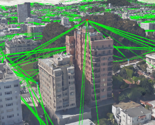 https://vexceldata.com/wp-content/uploads/2022/09/Screen-Shot-2022-09-26-at-4.54.00-PM.png
560
779
vexcel
https://vexceldata.com/wp-content/uploads/2021/12/VEXCEL-Data-Program.png
vexcel2022-09-26 22:53:212026-04-14 15:35:47The Future of Telecom Planning at Mobile World Congress
https://vexceldata.com/wp-content/uploads/2022/09/Screen-Shot-2022-09-26-at-4.54.00-PM.png
560
779
vexcel
https://vexceldata.com/wp-content/uploads/2021/12/VEXCEL-Data-Program.png
vexcel2022-09-26 22:53:212026-04-14 15:35:47The Future of Telecom Planning at Mobile World Congress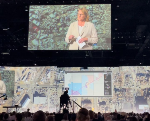 https://vexceldata.com/wp-content/uploads/2022/07/Screen-Shot-2022-07-19-at-11.40.19-AM.png
564
1117
vexcel
https://vexceldata.com/wp-content/uploads/2021/12/VEXCEL-Data-Program.png
vexcel2022-07-19 18:38:562026-04-14 15:50:14Esri UC 2022 – Full of Excitement and Announcement
https://vexceldata.com/wp-content/uploads/2022/07/Screen-Shot-2022-07-19-at-11.40.19-AM.png
564
1117
vexcel
https://vexceldata.com/wp-content/uploads/2021/12/VEXCEL-Data-Program.png
vexcel2022-07-19 18:38:562026-04-14 15:50:14Esri UC 2022 – Full of Excitement and Announcement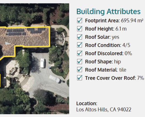 https://vexceldata.com/wp-content/uploads/2022/07/Screen-Shot-2022-07-07-at-10.20.16-PM.png
456
1249
vexcel
https://vexceldata.com/wp-content/uploads/2021/12/VEXCEL-Data-Program.png
vexcel2022-07-08 04:26:302022-07-08 04:26:30Announcing Building Attributes for Millions of Residential Properties in 26 Countries
https://vexceldata.com/wp-content/uploads/2022/07/Screen-Shot-2022-07-07-at-10.20.16-PM.png
456
1249
vexcel
https://vexceldata.com/wp-content/uploads/2021/12/VEXCEL-Data-Program.png
vexcel2022-07-08 04:26:302022-07-08 04:26:30Announcing Building Attributes for Millions of Residential Properties in 26 Countries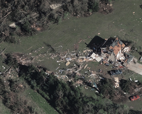 https://vexceldata.com/wp-content/uploads/2022/05/Tornado_Andover-_US-KS-9.jpeg
576
1024
vexcel
https://vexceldata.com/wp-content/uploads/2021/12/VEXCEL-Data-Program.png
vexcel2022-05-27 21:18:202026-04-14 15:30:22Aerial Imagery for Catastrophic Weather
https://vexceldata.com/wp-content/uploads/2022/05/Tornado_Andover-_US-KS-9.jpeg
576
1024
vexcel
https://vexceldata.com/wp-content/uploads/2021/12/VEXCEL-Data-Program.png
vexcel2022-05-27 21:18:202026-04-14 15:30:22Aerial Imagery for Catastrophic Weather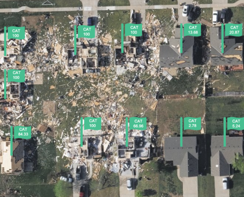 https://vexceldata.com/wp-content/uploads/2022/05/Screen-Shot-2022-05-20-at-11.15.12-AM.png
532
711
vexcel
https://vexceldata.com/wp-content/uploads/2021/12/VEXCEL-Data-Program.png
vexcel2022-05-20 20:01:342022-05-20 20:01:34Announcing Elements: Damage Assessment – Catastrophe Analytics
https://vexceldata.com/wp-content/uploads/2022/05/Screen-Shot-2022-05-20-at-11.15.12-AM.png
532
711
vexcel
https://vexceldata.com/wp-content/uploads/2021/12/VEXCEL-Data-Program.png
vexcel2022-05-20 20:01:342022-05-20 20:01:34Announcing Elements: Damage Assessment – Catastrophe Analytics https://vexceldata.com/wp-content/uploads/2024/12/banner-36.163623-86.776919-scaled.jpg
1440
2560
vexcel
https://vexceldata.com/wp-content/uploads/2021/12/VEXCEL-Data-Program.png
vexcel2022-01-25 17:03:562026-04-14 15:50:17How the Tennessee State Government is Using High-Res Aerial Imagery to Streamline 911 Response
https://vexceldata.com/wp-content/uploads/2024/12/banner-36.163623-86.776919-scaled.jpg
1440
2560
vexcel
https://vexceldata.com/wp-content/uploads/2021/12/VEXCEL-Data-Program.png
vexcel2022-01-25 17:03:562026-04-14 15:50:17How the Tennessee State Government is Using High-Res Aerial Imagery to Streamline 911 Response
