 https://vexceldata.com/wp-content/uploads/2024/11/true-ortho-39.070485-95.713393.jpg
1068
1900
vexcel
https://vexceldata.com/wp-content/uploads/2021/12/VEXCEL-Data-Program.png
vexcel2024-11-20 09:57:432026-04-14 15:46:58Bring GIS Day to Life with Powerful Data Analytics & Aerial Imagery
https://vexceldata.com/wp-content/uploads/2024/11/true-ortho-39.070485-95.713393.jpg
1068
1900
vexcel
https://vexceldata.com/wp-content/uploads/2021/12/VEXCEL-Data-Program.png
vexcel2024-11-20 09:57:432026-04-14 15:46:58Bring GIS Day to Life with Powerful Data Analytics & Aerial Imagery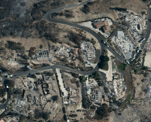 https://vexceldata.com/wp-content/uploads/2024/11/gray-sky-mountain-fireca_34.247795_-119.048936.jpg
1152
2048
kris.wagner
https://vexceldata.com/wp-content/uploads/2021/12/VEXCEL-Data-Program.png
kris.wagner2024-11-11 10:33:102024-11-11 13:07:47Gray Sky: Mountain Fire, CA
https://vexceldata.com/wp-content/uploads/2024/11/gray-sky-mountain-fireca_34.247795_-119.048936.jpg
1152
2048
kris.wagner
https://vexceldata.com/wp-content/uploads/2021/12/VEXCEL-Data-Program.png
kris.wagner2024-11-11 10:33:102024-11-11 13:07:47Gray Sky: Mountain Fire, CA https://vexceldata.com/wp-content/uploads/2024/11/40.207932-75.046765jpg.jpg
923
1640
vexcel
https://vexceldata.com/wp-content/uploads/2021/12/VEXCEL-Data-Program.png
vexcel2024-11-07 14:58:102026-04-14 15:54:15New API Services for Elements 2.0
https://vexceldata.com/wp-content/uploads/2024/11/40.207932-75.046765jpg.jpg
923
1640
vexcel
https://vexceldata.com/wp-content/uploads/2021/12/VEXCEL-Data-Program.png
vexcel2024-11-07 14:58:102026-04-14 15:54:15New API Services for Elements 2.0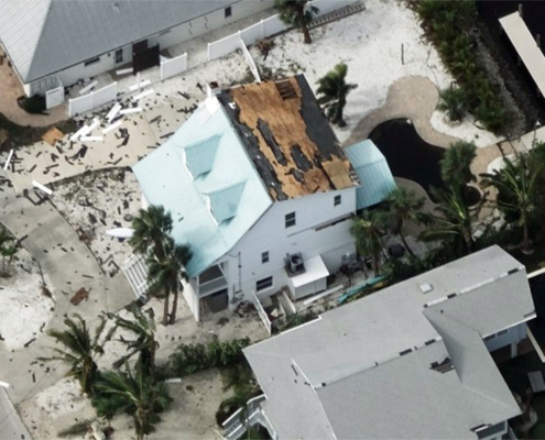 https://vexceldata.com/wp-content/uploads/2024/10/27.523919-82.729011-Oblique-HurricaneMilton.jpg
579
1030
kris.wagner
https://vexceldata.com/wp-content/uploads/2021/12/VEXCEL-Data-Program.png
kris.wagner2024-10-23 10:25:102024-11-07 10:33:33Vexcel Collects High-Resolution Aerial Imagery After Hurricane Milton
https://vexceldata.com/wp-content/uploads/2024/10/27.523919-82.729011-Oblique-HurricaneMilton.jpg
579
1030
kris.wagner
https://vexceldata.com/wp-content/uploads/2021/12/VEXCEL-Data-Program.png
kris.wagner2024-10-23 10:25:102024-11-07 10:33:33Vexcel Collects High-Resolution Aerial Imagery After Hurricane Milton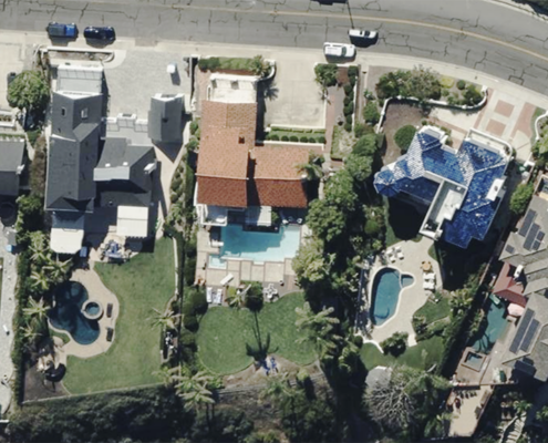 https://vexceldata.com/wp-content/uploads/2024/03/Ortho-SanClemente-CA-33.429051-117.600331.png
576
1024
vexcel
https://vexceldata.com/wp-content/uploads/2021/12/VEXCEL-Data-Program.png
vexcel2024-10-09 16:00:582024-10-09 16:00:58Insurance Trailblazer Orion180 Enhances Underwriting and Claims Operations with Vexcel’s Aerial Imagery and Property Analytics
https://vexceldata.com/wp-content/uploads/2024/03/Ortho-SanClemente-CA-33.429051-117.600331.png
576
1024
vexcel
https://vexceldata.com/wp-content/uploads/2021/12/VEXCEL-Data-Program.png
vexcel2024-10-09 16:00:582024-10-09 16:00:58Insurance Trailblazer Orion180 Enhances Underwriting and Claims Operations with Vexcel’s Aerial Imagery and Property Analytics https://vexceldata.com/wp-content/uploads/2024/10/Hurricane-Milton-St_Petersburg_FL_27.768165_-82.654007-1500x844-1.jpg
844
1500
jody
https://vexceldata.com/wp-content/uploads/2021/12/VEXCEL-Data-Program.png
jody2024-10-07 15:48:042024-11-04 16:33:47Gray Sky Event: Hurricane Milton
https://vexceldata.com/wp-content/uploads/2024/10/Hurricane-Milton-St_Petersburg_FL_27.768165_-82.654007-1500x844-1.jpg
844
1500
jody
https://vexceldata.com/wp-content/uploads/2021/12/VEXCEL-Data-Program.png
jody2024-10-07 15:48:042024-11-04 16:33:47Gray Sky Event: Hurricane Milton https://vexceldata.com/wp-content/uploads/2024/08/Boca_Raton_FL_USA_west_ortho_26.325454_-80.jpg
720
1280
jody
https://vexceldata.com/wp-content/uploads/2021/12/VEXCEL-Data-Program.png
jody2024-10-02 09:51:182026-02-12 13:38:11The Importance of Ground Control Points and Accuracy in Aerial Imagery
https://vexceldata.com/wp-content/uploads/2024/08/Boca_Raton_FL_USA_west_ortho_26.325454_-80.jpg
720
1280
jody
https://vexceldata.com/wp-content/uploads/2021/12/VEXCEL-Data-Program.png
jody2024-10-02 09:51:182026-02-12 13:38:11The Importance of Ground Control Points and Accuracy in Aerial Imagery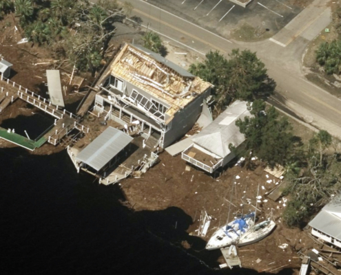 https://vexceldata.com/wp-content/uploads/2024/10/Hurricane-Helene-Steinhatchee-FL_29.670209_-83.383148.jpg
1152
2048
jody
https://vexceldata.com/wp-content/uploads/2021/12/VEXCEL-Data-Program.png
jody2024-09-26 15:57:492024-11-04 16:34:12Gray Sky: Hurricane Helene
https://vexceldata.com/wp-content/uploads/2024/10/Hurricane-Helene-Steinhatchee-FL_29.670209_-83.383148.jpg
1152
2048
jody
https://vexceldata.com/wp-content/uploads/2021/12/VEXCEL-Data-Program.png
jody2024-09-26 15:57:492024-11-04 16:34:12Gray Sky: Hurricane Helene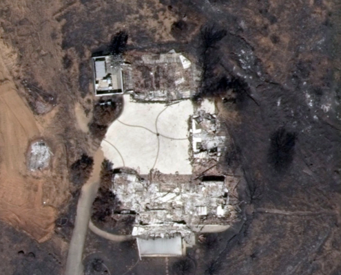 https://vexceldata.com/wp-content/uploads/2024/11/33.651434-117.420934-AFter.jpg
576
1024
jody
https://vexceldata.com/wp-content/uploads/2021/12/VEXCEL-Data-Program.png
jody2024-09-19 08:27:482026-04-14 15:43:33Gray Sky: Trabuco Canyon – Airport Fire in CA
https://vexceldata.com/wp-content/uploads/2024/11/33.651434-117.420934-AFter.jpg
576
1024
jody
https://vexceldata.com/wp-content/uploads/2021/12/VEXCEL-Data-Program.png
jody2024-09-19 08:27:482026-04-14 15:43:33Gray Sky: Trabuco Canyon – Airport Fire in CA
