
Tag Archive for: aerial maps
 https://vexceldata.com/wp-content/uploads/2025/02/State-promo-image.jpg
576
1026
vexcel
https://vexceldata.com/wp-content/uploads/2021/12/VEXCEL-Data-Program.png
vexcel2025-02-06 15:40:182026-04-14 15:46:56See Imagery & Data in 49 States
https://vexceldata.com/wp-content/uploads/2025/02/State-promo-image.jpg
576
1026
vexcel
https://vexceldata.com/wp-content/uploads/2021/12/VEXCEL-Data-Program.png
vexcel2025-02-06 15:40:182026-04-14 15:46:56See Imagery & Data in 49 States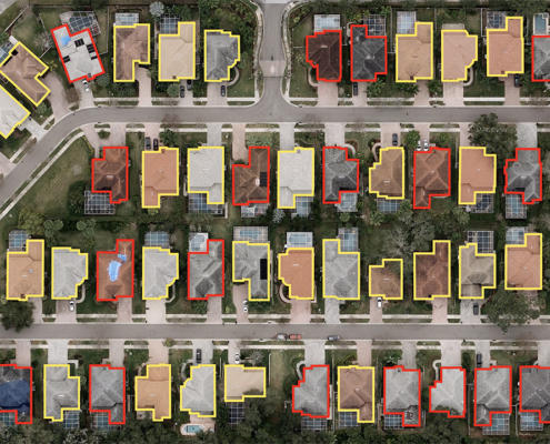 https://vexceldata.com/wp-content/uploads/2022/02/28.004201-82.706977.jpg
720
1280
vexcel
https://vexceldata.com/wp-content/uploads/2021/12/VEXCEL-Data-Program.png
vexcel2022-02-18 17:05:132026-04-14 15:35:36Connecting Insurers to Valuable Imagery with Metadata at Verisk Elevate
https://vexceldata.com/wp-content/uploads/2022/02/28.004201-82.706977.jpg
720
1280
vexcel
https://vexceldata.com/wp-content/uploads/2021/12/VEXCEL-Data-Program.png
vexcel2022-02-18 17:05:132026-04-14 15:35:36Connecting Insurers to Valuable Imagery with Metadata at Verisk Elevate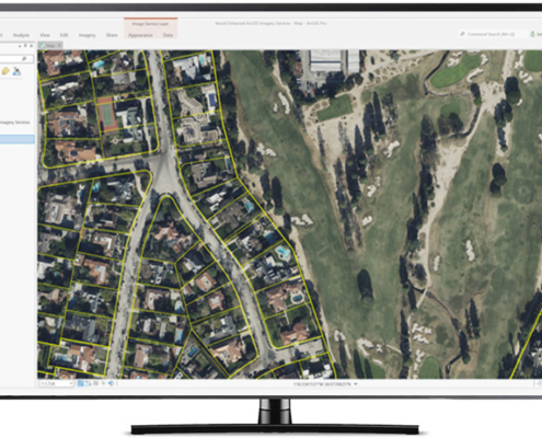 https://vexceldata.com/wp-content/uploads/2022/03/ArcGIS_propertylines-1.jpeg
576
1024
vexcel
https://vexceldata.com/wp-content/uploads/2021/12/VEXCEL-Data-Program.png
vexcel2022-02-15 08:23:552024-10-08 08:37:03Announcing Image Services for ArcGIS
https://vexceldata.com/wp-content/uploads/2022/03/ArcGIS_propertylines-1.jpeg
576
1024
vexcel
https://vexceldata.com/wp-content/uploads/2021/12/VEXCEL-Data-Program.png
vexcel2022-02-15 08:23:552024-10-08 08:37:03Announcing Image Services for ArcGIS https://vexceldata.com/wp-content/uploads/2022/02/Denver_CO_oblique_39.754691_-105.002128-1-1030x573-copy-1.jpg
720
1280
vexcel
https://vexceldata.com/wp-content/uploads/2021/12/VEXCEL-Data-Program.png
vexcel2022-02-11 21:33:572026-04-14 15:49:46Geo Week 2022 Showcases New SDK, Growing Imagery Library, and Integration Updates
https://vexceldata.com/wp-content/uploads/2022/02/Denver_CO_oblique_39.754691_-105.002128-1-1030x573-copy-1.jpg
720
1280
vexcel
https://vexceldata.com/wp-content/uploads/2021/12/VEXCEL-Data-Program.png
vexcel2022-02-11 21:33:572026-04-14 15:49:46Geo Week 2022 Showcases New SDK, Growing Imagery Library, and Integration Updates https://vexceldata.com/wp-content/uploads/2022/02/Elements1.png
348
754
Steve Lombardi
https://vexceldata.com/wp-content/uploads/2021/12/VEXCEL-Data-Program.png
Steve Lombardi2022-02-10 18:36:322026-04-14 15:54:15Building Geometry and Property Attributes? It’s Elements-ary, dear Watson
https://vexceldata.com/wp-content/uploads/2022/02/Elements1.png
348
754
Steve Lombardi
https://vexceldata.com/wp-content/uploads/2021/12/VEXCEL-Data-Program.png
Steve Lombardi2022-02-10 18:36:322026-04-14 15:54:15Building Geometry and Property Attributes? It’s Elements-ary, dear Watson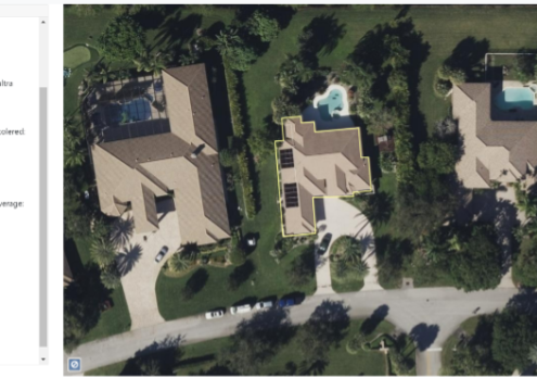 https://vexceldata.com/wp-content/uploads/2022/02/Elements1-1.png
348
754
Steve Lombardi
https://vexceldata.com/wp-content/uploads/2021/12/VEXCEL-Data-Program.png
Steve Lombardi2022-02-10 11:58:462026-04-14 15:54:16Getting the Most out of Imagery with Elements Property Information
https://vexceldata.com/wp-content/uploads/2022/02/Elements1-1.png
348
754
Steve Lombardi
https://vexceldata.com/wp-content/uploads/2021/12/VEXCEL-Data-Program.png
Steve Lombardi2022-02-10 11:58:462026-04-14 15:54:16Getting the Most out of Imagery with Elements Property Information https://vexceldata.com/wp-content/uploads/2022/03/Screen-Shot-2022-03-01-at-8.16.51-AM.png
601
1073
vexcel
https://vexceldata.com/wp-content/uploads/2021/12/VEXCEL-Data-Program.png
vexcel2022-02-08 07:59:032024-10-08 08:37:04Introducing MapControl SDK
https://vexceldata.com/wp-content/uploads/2022/03/Screen-Shot-2022-03-01-at-8.16.51-AM.png
601
1073
vexcel
https://vexceldata.com/wp-content/uploads/2021/12/VEXCEL-Data-Program.png
vexcel2022-02-08 07:59:032024-10-08 08:37:04Introducing MapControl SDK https://vexceldata.com/wp-content/uploads/2021/02/Boston_MA__Aerial_Image_Oblique.jpg
576
1024
vexcel
https://vexceldata.com/wp-content/uploads/2021/12/VEXCEL-Data-Program.png
vexcel2021-03-08 23:12:302026-04-14 15:51:06Introducing VEXCELDATA.COM: the technology, the products, the use cases
https://vexceldata.com/wp-content/uploads/2021/02/Boston_MA__Aerial_Image_Oblique.jpg
576
1024
vexcel
https://vexceldata.com/wp-content/uploads/2021/12/VEXCEL-Data-Program.png
vexcel2021-03-08 23:12:302026-04-14 15:51:06Introducing VEXCELDATA.COM: the technology, the products, the use cases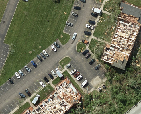 Geospatial Insurance Consortium
https://vexceldata.com/wp-content/uploads/2020/12/Dayton_OH_Aerial_Image_Tornado-1.jpg
563
1000
vexcel
https://vexceldata.com/wp-content/uploads/2021/12/VEXCEL-Data-Program.png
vexcel2020-12-16 23:43:412026-02-21 21:49:54Tornados, Hurricanes, Wildfires, Oh My—A Year to Remember with Gray Sky
Geospatial Insurance Consortium
https://vexceldata.com/wp-content/uploads/2020/12/Dayton_OH_Aerial_Image_Tornado-1.jpg
563
1000
vexcel
https://vexceldata.com/wp-content/uploads/2021/12/VEXCEL-Data-Program.png
vexcel2020-12-16 23:43:412026-02-21 21:49:54Tornados, Hurricanes, Wildfires, Oh My—A Year to Remember with Gray Sky