
 https://vexceldata.com/wp-content/uploads/2017/09/osprey-collects-09.02.2017-1-1210x423-1.jpg
423
1210
kris.wagner
https://vexceldata.com/wp-content/uploads/2021/12/VEXCEL-Data-Program.png
kris.wagner2017-09-02 14:18:332024-10-08 08:42:24Update from the Field 09.02.2017
https://vexceldata.com/wp-content/uploads/2017/09/osprey-collects-09.02.2017-1-1210x423-1.jpg
423
1210
kris.wagner
https://vexceldata.com/wp-content/uploads/2021/12/VEXCEL-Data-Program.png
kris.wagner2017-09-02 14:18:332024-10-08 08:42:24Update from the Field 09.02.2017 https://vexceldata.com/wp-content/uploads/2017/09/Quantum-completed-block.png
755
443
kris.wagner
https://vexceldata.com/wp-content/uploads/2021/12/VEXCEL-Data-Program.png
kris.wagner2017-09-02 13:38:132024-10-08 08:42:24Update from the Field 09.02.17 13:30 MDT
https://vexceldata.com/wp-content/uploads/2017/09/Quantum-completed-block.png
755
443
kris.wagner
https://vexceldata.com/wp-content/uploads/2021/12/VEXCEL-Data-Program.png
kris.wagner2017-09-02 13:38:132024-10-08 08:42:24Update from the Field 09.02.17 13:30 MDT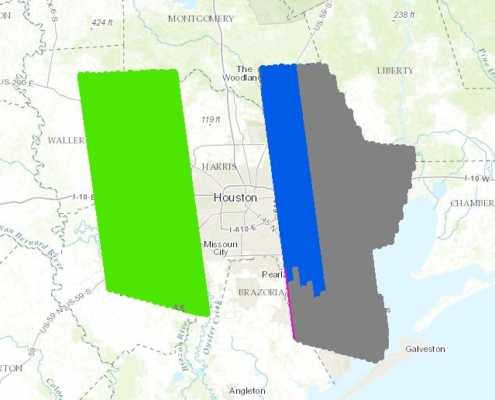 https://vexceldata.com/wp-content/uploads/2017/09/sanborn-houston-progress-09.02.2017-am.jpg
516
843
kris.wagner
https://vexceldata.com/wp-content/uploads/2021/12/VEXCEL-Data-Program.png
kris.wagner2017-09-02 12:50:492024-10-08 08:42:24Update from the Field 09.02.2017 12:45 MDT
https://vexceldata.com/wp-content/uploads/2017/09/sanborn-houston-progress-09.02.2017-am.jpg
516
843
kris.wagner
https://vexceldata.com/wp-content/uploads/2021/12/VEXCEL-Data-Program.png
kris.wagner2017-09-02 12:50:492024-10-08 08:42:24Update from the Field 09.02.2017 12:45 MDT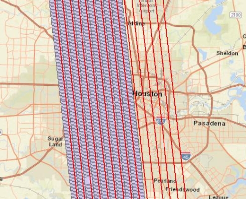 https://vexceldata.com/wp-content/uploads/2017/09/Quantum-lines-1-9-completed-591x423-1.jpg
423
591
kris.wagner
https://vexceldata.com/wp-content/uploads/2021/12/VEXCEL-Data-Program.png
kris.wagner2017-09-02 10:48:292024-10-08 08:42:25Update from the Field 09.02.17 10:00 A.M. MDT
https://vexceldata.com/wp-content/uploads/2017/09/Quantum-lines-1-9-completed-591x423-1.jpg
423
591
kris.wagner
https://vexceldata.com/wp-content/uploads/2021/12/VEXCEL-Data-Program.png
kris.wagner2017-09-02 10:48:292024-10-08 08:42:25Update from the Field 09.02.17 10:00 A.M. MDT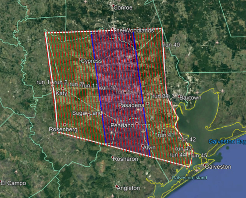 https://vexceldata.com/wp-content/uploads/2021/06/07-AOI-division.jpg
657
847
kris.wagner
https://vexceldata.com/wp-content/uploads/2021/12/VEXCEL-Data-Program.png
kris.wagner2017-09-01 20:00:152024-10-08 08:42:25Update from the field
https://vexceldata.com/wp-content/uploads/2021/12/VEXCEL-Data-Program.png
0
0
kris.wagner
https://vexceldata.com/wp-content/uploads/2021/12/VEXCEL-Data-Program.png
kris.wagner2017-09-01 15:46:472024-10-08 08:42:25Dramatic Satellite Photos Show Texas Towns Underwater
https://vexceldata.com/wp-content/uploads/2021/06/07-AOI-division.jpg
657
847
kris.wagner
https://vexceldata.com/wp-content/uploads/2021/12/VEXCEL-Data-Program.png
kris.wagner2017-09-01 20:00:152024-10-08 08:42:25Update from the field
https://vexceldata.com/wp-content/uploads/2021/12/VEXCEL-Data-Program.png
0
0
kris.wagner
https://vexceldata.com/wp-content/uploads/2021/12/VEXCEL-Data-Program.png
kris.wagner2017-09-01 15:46:472024-10-08 08:42:25Dramatic Satellite Photos Show Texas Towns Underwater