Vexcel Data Program
  • Products
    • Overview
    • Oblique
    • Ortho
    • 3D Cities
    • Elements AI
    • Elevate
    • Gray Sky
    • Multispectral
    • On Demand
  • Intelligence
  • Industries
    • Overview
    • Government
      • Property Assessment
      • Transportation
      • Public Safety
      • Urban Planning
      • Public Works
    • Telecom
    • Utilities
    • Insurance
      • Underwriting
      • Claims
      • SIU
    • Financial Services
    • Energy
    • AEC
    • HD Maps
    • Smart Cities
    • University Access Program
  • Coverage
    • All Countries
    • United States
    • Australia
    • Germany
    • Japan
    • United Kingdom
  • Platform
    • Overview
    • Image Services for ArcGIS
    • MapControl SDK
    • Evaluations
    • Partners
    • Viewer
  • Stories
  • Login
  • Get a Demo
  • Menu Menu

Adaptive Motion Compensation: Motion Happens. Blur Doesn’t Have To.

January 15, 2026
…
https://vexceldata.com/wp-content/uploads/2026/01/Netherlands-Promo-image.jpg 576 826 vexcel https://vexceldata.com/wp-content/uploads/2021/12/VEXCEL-Data-Program.png vexcel2026-01-15 10:53:472026-02-12 13:28:24Adaptive Motion Compensation: Motion Happens. Blur Doesn’t Have To.

Inside Vexcel: Precision By Design – How UltraCam Delivers the Best Data

December 18, 2025
…
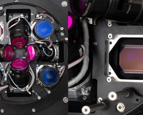
https://vexceldata.com/wp-content/uploads/2025/12/Sony-lenses.jpg 576 1024 vexcel https://vexceldata.com/wp-content/uploads/2021/12/VEXCEL-Data-Program.png vexcel2025-12-18 09:34:322026-02-12 13:29:10Inside Vexcel: Precision By Design – How UltraCam Delivers the Best Data

Need Fast Access to Imagery and Data in ArcGIS? Vexcel Has You Covered

July 9, 2025
…
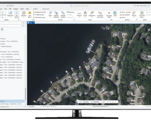
https://vexceldata.com/wp-content/uploads/2025/07/ArcGIS-Computer-Screen.png 777 1280 vexcel https://vexceldata.com/wp-content/uploads/2021/12/VEXCEL-Data-Program.png vexcel2025-07-09 08:06:462025-07-09 08:06:46Need Fast Access to Imagery and Data in ArcGIS? Vexcel Has You Covered

Rooftop Intel: Where AI Meets the Shingles

June 3, 2025
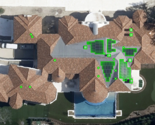
https://vexceldata.com/wp-content/uploads/2025/06/VEX-616-GRA-Elements-Roofing-Items-for-Blog-03.jpg 576 1024 vexcel https://vexceldata.com/wp-content/uploads/2021/12/VEXCEL-Data-Program.png vexcel2025-06-03 09:10:402025-12-08 11:54:14Rooftop Intel: Where AI Meets the Shingles

Vexcel imagery used in latest Microsoft Flight Simulator release

November 14, 2023
https://vexceldata.com/wp-content/uploads/2023/11/MSFS_WU15_Screenshots_01-scaled-1.jpg 1440 2560 vexcel https://vexceldata.com/wp-content/uploads/2021/12/VEXCEL-Data-Program.png vexcel2023-11-14 11:53:242023-11-14 11:53:24Vexcel imagery used in latest Microsoft Flight Simulator release

Citizens Adopts Aerial Imagery Analytics–Powered by Vexcel–from Verisk

November 13, 2023
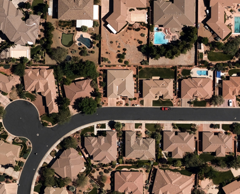
https://vexceldata.com/wp-content/uploads/2022/02/St-George_Aerial_Image_Ortho.jpg 576 1024 vexcel https://vexceldata.com/wp-content/uploads/2021/12/VEXCEL-Data-Program.png vexcel2023-11-13 16:46:312023-11-13 16:46:31Citizens Adopts Aerial Imagery Analytics–Powered by Vexcel–from Verisk

Vexcel Partnering with LexisNexis for Rooftop Solution

November 10, 2023
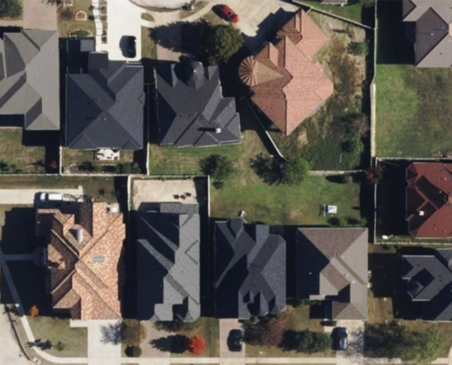
https://vexceldata.com/wp-content/uploads/2023/10/Irving-texas-us-ortho-residential-32.844341_-97.013052-copy.jpg 576 1024 vexcel https://vexceldata.com/wp-content/uploads/2021/12/VEXCEL-Data-Program.png vexcel2023-11-10 15:21:212024-06-14 09:51:19Vexcel Partnering with LexisNexis for Rooftop Solution

Post-Catastrophe Damage Assessment Made Easy

March 8, 2023
/
0 Comments
…
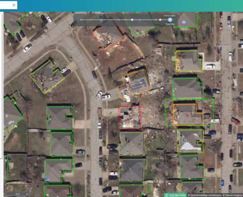
https://vexceldata.com/wp-content/uploads/2023/03/Image1.png 1294 2556 vexcel https://vexceldata.com/wp-content/uploads/2021/12/VEXCEL-Data-Program.png vexcel2023-03-08 15:17:552024-09-24 10:50:14Post-Catastrophe Damage Assessment Made Easy

2022 was our BIGGEST year yet: Big Data, New Products, More Countries

December 27, 2022
…
https://vexceldata.com/wp-content/uploads/2022/12/Instagram_1080x1080_V2.png 1080 1080 vexcel https://vexceldata.com/wp-content/uploads/2021/12/VEXCEL-Data-Program.png vexcel2022-12-27 22:23:122023-01-11 13:20:472022 was our BIGGEST year yet: Big Data, New Products, More Countries

2022: A Transformational Year—More Members, More Images, and More Property Insights

December 27, 2022
/
0 Comments
…
https://vexceldata.com/wp-content/uploads/2022/12/Instagram_1080x1080_V2-1.png 1080 1080 vexcel https://vexceldata.com/wp-content/uploads/2021/12/VEXCEL-Data-Program.png vexcel2022-12-27 16:31:372024-09-24 10:56:302022: A Transformational Year—More Members, More Images, and More Property Insights
Page 1 of 3123

Pages

  • 3D Cities
  • A Complete End-to-End Imagery Solution
  • About
  • Adelaide
  • AEC
  • AI Labs Thank You
  • Alabama
  • Arizona
  • Arkansas
  • Australia
  • Austria
  • Beautiful Earth
  • Become A Partner
  • Belgium
  • Bosnia & Herzegovina
  • Brazil
  • Brisbane
  • Building Attributes
  • Building the Future of Communication Networks
  • California
  • Canada
  • Canberra
  • Cesium Sydney
  • cesium-adelaide
  • Cesium-Brisbane
  • cesium-canberra
  • Cesium-Melbourne
  • Cesium-Perth
  • Claims
  • Colorado
  • Connecticut
  • Countries
  • Country CTA Section
  • Croatia
  • Czechia
  • Damage Assessment
  • Damage Report
  • Damage Reports
  • Damage Reports Download
  • Delaware
  • Denmark
  • Disaster Response
  • Elements AI
  • Elements Coverage by Product
  • Elevate
  • END USER LICENSE AGREEMENT
  • Energy
  • Esri UC 2023
  • Estonia
  • Evaluation CTA
  • Evaluations
  • Excellence
  • Financial Services
  • Finland
  • Florida
  • France
  • GEO Business 2021
  • Georgia
  • Germany
  • GIC
  • GIC CTA
  • GIC-Vexcel Merger Section
  • Gold Coast
  • Government
  • Gray Sky
  • Hawaii
  • HD Maps
  • Help Center
  • Help Center Chat
  • homepage AI
  • Hungary
  • Idaho
  • Illinois
  • Image Services for ArcGIS
  • India
  • Indiana
  • Industries
  • Insurance
  • Intelligence
  • Intelligence Demo
  • Iowa
  • Ireland
  • Italy
  • Japan
  • Kansas
  • Kentucky
  • Latvia
  • Liechtenstein
  • Lithuania
  • Louisiana
  • Luxembourg
  • Maine
  • MapControl SDK
  • Maryland
  • Massachusetts
  • Melbourne
  • Michigan
  • Minnesota
  • Mississippi
  • Missouri
  • Monaco
  • Montana
  • Multispectral
  • Nebraska
  • Netherlands
  • Nevada
  • New Hampshire
  • New Jersey
  • New Mexico
  • New York
  • New Zealand
  • Newsletter
  • North Carolina
  • North Dakota
  • Norway
  • Oblique
  • Ohio
  • Oklahoma
  • On Demand
  • On Demand CTA
  • Oregon
  • Ortho
  • Partners
  • Partners CTA
  • Pennsylvania
  • Perth
  • Platform
  • Poland
  • Portugal
  • Privacy
  • Products
  • Property Assessment
  • Property Assessment
  • Property Attributes
  • Property Report Download
  • Property Reports
  • Public Safety
  • Public Works
  • Puerto Rico
  • Request a Demo
  • Request a Demo for Esri
  • Request Demo – Government
  • Request More Info
  • Rhode Island
  • Roadways
  • San Marino
  • simple checkout
  • SIU
  • Slovakia
  • Slovenia
  • Smart Cities
  • Smart Cities
  • South Africa
  • South Carolina
  • South Dakota
  • Spain
  • Stories
  • Sweden
  • Switzerland
  • Sydney
  • Technology
  • Telecom
  • Temp Homepage
  • Tennessee
  • Terms of Use
  • Texas
  • Thank You
  • Transportation
  • U.S. Virgin Islands
  • Underwriting
  • United Kingdom
  • United States
  • University Access Program
  • Urban Planning
  • US Collection
  • Use Case: State of Tennessee
  • Use Case: State of Tennessee Download
  • Utah
  • Utilities
  • Vatican City
  • VDP CTA
  • Vermont
  • Vexcel Countries
  • Vexcel Data
  • Vexcel Data Program | Aerial Imagery
  • Vexcel Intelligence: Find communication towers with room for additional 5G equipment in Japan.
  • Vexcel Intelligence: Find distressed homes in luxury neighborhoods in South Africa.
  • Vexcel Intelligence: Find Mediterranean-style homes with an in-ground pool and tennis court use case
  • Video: 2022 Year in Review
  • Video: Supercharge Your Location Intelligence with Digital Surface Models
  • Videos
  • Viewer
  • Viewer CTA
  • Virginia
  • Washington
  • Washington, D.C.
  • West Virginia
  • Wisconsin
  • Wyoming

Categories

  • API
  • Case Studies
  • Claims
  • Disaster Imagery
  • Esri
  • Events
  • Flooding
  • Government
  • Gray Sky
  • Hail
  • Hurricane
  • Ida
  • Imagery
  • Insurance
  • Intelligence
  • News
  • Partner
  • Partners
  • Pillar
  • Product
  • SIU
  • Technology
  • Tornado
  • Uncategorized
  • Utilities
  • Vexcel Data Program
  • Vexcel Platform
  • Viewer
  • Wildfire

Archive

  • February 2026
  • January 2026
  • December 2025
  • November 2025
  • October 2025
  • September 2025
  • August 2025
  • July 2025
  • June 2025
  • May 2025
  • April 2025
  • March 2025
  • February 2025
  • January 2025
  • December 2024
  • November 2024
  • October 2024
  • September 2024
  • August 2024
  • July 2024
  • June 2024
  • May 2024
  • April 2024
  • March 2024
  • February 2024
  • January 2024
  • December 2023
  • November 2023
  • October 2023
  • September 2023
  • August 2023
  • June 2023
  • May 2023
  • April 2023
  • March 2023
  • February 2023
  • January 2023
  • December 2022
  • November 2022
  • October 2022
  • September 2022
  • August 2022
  • July 2022
  • May 2022
  • April 2022
  • March 2022
  • February 2022
  • January 2022
  • December 2021
  • November 2021
  • October 2021
  • September 2021
  • August 2021
  • July 2021
  • June 2021
  • May 2021
  • April 2021
  • March 2021
  • February 2021
  • January 2021
  • December 2020
  • September 2020
  • August 2020
  • May 2020
  • April 2020
  • January 2020

Products

Oblique
Ortho
3D Cities
Elements
Elevate
Gray Sky
Multispectral
On Demand

Coverage 
Countries

Industries

Government
Telecom
Utilities
Insurance
Financial Services
Energy
AEC
HD Maps
Smart Cities

Intelligence

Platform

Overview
Partners
Viewer

About
Stories
Videos
Careers
Help Center

Follow Us


Global Leaders in Aerial Imaging.

Vexcel provides industry-leading camera sensors, a dedicated fleet of fixed-wing aircraft, and the largest, most accurate aerial imagery and geospatial data program on the planet.

Learn More
 width=

Large-format UltraCam cameras & sensors.
vexcel-imaging.com

Aerial surveys by fixed-wing aircraft.
kasurveys.com

Aerial imagery and data for government and business.
vexceldata.com

© Vexcel Imaging US, Inc.
  • Privacy Policy
  • Terms of Use
  • EULA
  • Worldwide
  • AU/NZ
Scroll to top

This site uses cookies. By continuing to browse the site, you are agreeing to our use of cookies.

Accept settingsHide notification onlySettings

Cookie and Privacy Settings


How we use cookies

We may request cookies to be set on your device. We use cookies to let us know when you visit our websites, how you interact with us, to enrich your user experience, and to customize your relationship with our website.

Click on the different category headings to find out more. You can also change some of your preferences. Note that blocking some types of cookies may impact your experience on our websites and the services we are able to offer.

Essential Website Cookies

These cookies are strictly necessary to provide you with services available through our website and to use some of its features.

Because these cookies are strictly necessary to deliver the website, refusing them will have impact how our site functions. You always can block or delete cookies by changing your browser settings and force blocking all cookies on this website. But this will always prompt you to accept/refuse cookies when revisiting our site.

We fully respect if you want to refuse cookies but to avoid asking you again and again kindly allow us to store a cookie for that. You are free to opt out any time or opt in for other cookies to get a better experience. If you refuse cookies we will remove all set cookies in our domain.

We provide you with a list of stored cookies on your computer in our domain so you can check what we stored. Due to security reasons we are not able to show or modify cookies from other domains. You can check these in your browser security settings.

Google Analytics Cookies

These cookies collect information that is used either in aggregate form to help us understand how our website is being used or how effective our marketing campaigns are, or to help us customize our website and application for you in order to enhance your experience.

If you do not want that we track your visit to our site you can disable tracking in your browser here:

Other external services

We also use different external services like Google Webfonts, Google Maps, and external Video providers. Since these providers may collect personal data like your IP address we allow you to block them here. Please be aware that this might heavily reduce the functionality and appearance of our site. Changes will take effect once you reload the page.

Google Webfont Settings:

Google Map Settings:

Google reCaptcha Settings:

Vimeo and Youtube video embeds:

Other cookies

The following cookies are also needed - You can choose if you want to allow them:

Privacy Policy

You can read about our cookies and privacy settings in detail on our Privacy Policy Page.

Accept settingsHide notification only