
 https://vexceldata.com/wp-content/uploads/2022/01/Part2_blog_Pic29.png
713
1195
vexcel
https://vexceldata.com/wp-content/uploads/2021/12/VEXCEL-Data-Program.png
vexcel2022-01-07 19:57:512022-02-10 13:14:06Let’s get technical (Pt 2): Using Python data science libraries on web map tiles
https://vexceldata.com/wp-content/uploads/2022/01/Part2_blog_Pic29.png
713
1195
vexcel
https://vexceldata.com/wp-content/uploads/2021/12/VEXCEL-Data-Program.png
vexcel2022-01-07 19:57:512022-02-10 13:14:06Let’s get technical (Pt 2): Using Python data science libraries on web map tiles https://vexceldata.com/wp-content/uploads/2021/12/Screen-Shot-2021-12-28-at-3.06.32-PM.png
1302
2156
vexcel
https://vexceldata.com/wp-content/uploads/2021/12/VEXCEL-Data-Program.png
vexcel2021-12-28 22:12:572024-06-14 09:57:26Pasco Corp Announced as Reseller of Urban Vexcel Data in Japan
https://vexceldata.com/wp-content/uploads/2021/12/Screen-Shot-2021-12-28-at-3.06.32-PM.png
1302
2156
vexcel
https://vexceldata.com/wp-content/uploads/2021/12/VEXCEL-Data-Program.png
vexcel2021-12-28 22:12:572024-06-14 09:57:26Pasco Corp Announced as Reseller of Urban Vexcel Data in Japan https://vexceldata.com/wp-content/uploads/2021/12/Screen-Shot-2021-12-22-at-9.45.19-AM.png
692
697
vexcel
https://vexceldata.com/wp-content/uploads/2021/12/VEXCEL-Data-Program.png
vexcel2021-12-22 17:00:202022-02-10 13:06:32Let’s get technical: Using Web Map Tiles in Python (Pt 1)
https://vexceldata.com/wp-content/uploads/2021/12/Screen-Shot-2021-12-22-at-9.45.19-AM.png
692
697
vexcel
https://vexceldata.com/wp-content/uploads/2021/12/VEXCEL-Data-Program.png
vexcel2021-12-22 17:00:202022-02-10 13:06:32Let’s get technical: Using Web Map Tiles in Python (Pt 1) https://vexceldata.com/wp-content/uploads/2021/12/Screen-Shot-2021-12-22-at-9.19.55-AM.png
954
940
vexcel
https://vexceldata.com/wp-content/uploads/2021/12/VEXCEL-Data-Program.png
vexcel2021-12-21 18:42:532022-02-10 13:16:402021 – A Year Full of Announcements
https://vexceldata.com/wp-content/uploads/2021/12/Screen-Shot-2021-12-22-at-9.19.55-AM.png
954
940
vexcel
https://vexceldata.com/wp-content/uploads/2021/12/VEXCEL-Data-Program.png
vexcel2021-12-21 18:42:532022-02-10 13:16:402021 – A Year Full of Announcements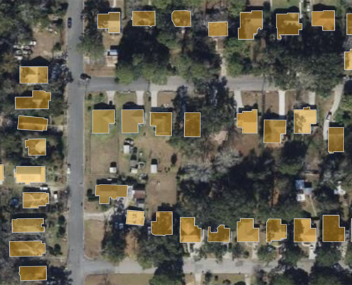 https://vexceldata.com/wp-content/uploads/2021/10/Feature-Blog-Vexcel-1024x576-1.jpg
576
1024
vexcel
https://vexceldata.com/wp-content/uploads/2021/12/VEXCEL-Data-Program.png
vexcel2021-10-04 23:40:062022-03-17 19:41:38NEW: Building Footprints and Property Attributes for U.S. & Australia
https://vexceldata.com/wp-content/uploads/2021/10/Feature-Blog-Vexcel-1024x576-1.jpg
576
1024
vexcel
https://vexceldata.com/wp-content/uploads/2021/12/VEXCEL-Data-Program.png
vexcel2021-10-04 23:40:062022-03-17 19:41:38NEW: Building Footprints and Property Attributes for U.S. & Australia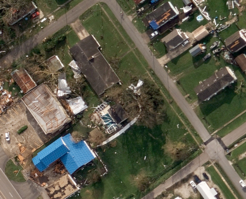 https://vexceldata.com/wp-content/uploads/2021/09/Screen-Shot-2021-09-01-at-10.55.29-AM.png
546
965
vexcel
https://vexceldata.com/wp-content/uploads/2021/12/VEXCEL-Data-Program.png
vexcel2021-09-01 16:58:492022-02-14 15:09:45Collecting Disaster Imagery: From Hurricanes to Wildfires and Beyond
https://vexceldata.com/wp-content/uploads/2021/09/Screen-Shot-2021-09-01-at-10.55.29-AM.png
546
965
vexcel
https://vexceldata.com/wp-content/uploads/2021/12/VEXCEL-Data-Program.png
vexcel2021-09-01 16:58:492022-02-14 15:09:45Collecting Disaster Imagery: From Hurricanes to Wildfires and Beyond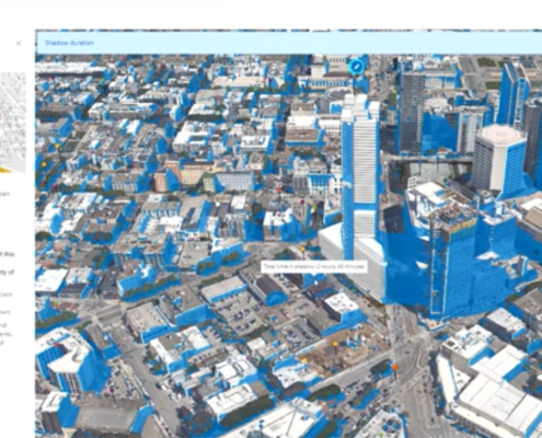 https://vexceldata.com/wp-content/uploads/2021/07/Screen-Shot-2021-07-12-at-2.40.45-PM.png
986
1903
vexcel
https://vexceldata.com/wp-content/uploads/2021/12/VEXCEL-Data-Program.png
vexcel2021-07-12 20:59:042021-07-12 21:23:53Vexcel Featured in Esri UC Plenary Session
https://vexceldata.com/wp-content/uploads/2021/07/Screen-Shot-2021-07-12-at-2.40.45-PM.png
986
1903
vexcel
https://vexceldata.com/wp-content/uploads/2021/12/VEXCEL-Data-Program.png
vexcel2021-07-12 20:59:042021-07-12 21:23:53Vexcel Featured in Esri UC Plenary Session https://vexceldata.com/wp-content/uploads/2021/05/200CocoBeachBoulevard-RioGrand-00745-PR.jpg
777
1362
vexcel
https://vexceldata.com/wp-content/uploads/2021/12/VEXCEL-Data-Program.png
vexcel2021-05-27 16:42:242021-06-10 16:11:05Introducing Puerto Rico: The Latest Addition to Our Capture Program
https://vexceldata.com/wp-content/uploads/2021/05/200CocoBeachBoulevard-RioGrand-00745-PR.jpg
777
1362
vexcel
https://vexceldata.com/wp-content/uploads/2021/12/VEXCEL-Data-Program.png
vexcel2021-05-27 16:42:242021-06-10 16:11:05Introducing Puerto Rico: The Latest Addition to Our Capture Program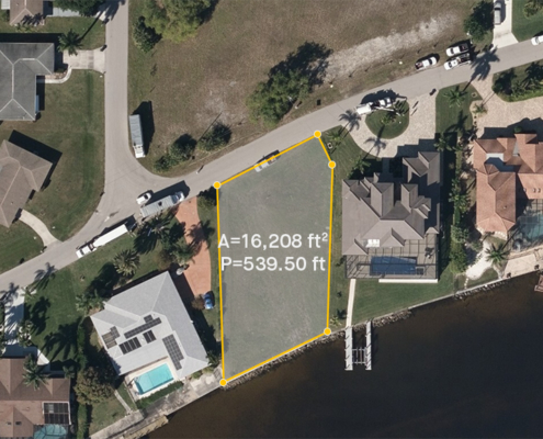 https://vexceldata.com/wp-content/uploads/2021/02/cape_coral_florida_ortho_aerameasurement.jpg
576
1024
vexcel
https://vexceldata.com/wp-content/uploads/2021/12/VEXCEL-Data-Program.png
vexcel2021-05-06 20:56:582021-05-06 20:56:58Fast-track Property Valuations with High-Res Aerial Imagery
https://vexceldata.com/wp-content/uploads/2021/02/cape_coral_florida_ortho_aerameasurement.jpg
576
1024
vexcel
https://vexceldata.com/wp-content/uploads/2021/12/VEXCEL-Data-Program.png
vexcel2021-05-06 20:56:582021-05-06 20:56:58Fast-track Property Valuations with High-Res Aerial Imagery https://vexceldata.com/wp-content/uploads/2021/03/DSM-Solar.png
2839
4959
Steve Lombardi
https://vexceldata.com/wp-content/uploads/2021/12/VEXCEL-Data-Program.png
Steve Lombardi2021-03-10 21:05:012024-06-11 14:00:41NEW: Digital Surface Model API Now Available
https://vexceldata.com/wp-content/uploads/2021/03/DSM-Solar.png
2839
4959
Steve Lombardi
https://vexceldata.com/wp-content/uploads/2021/12/VEXCEL-Data-Program.png
Steve Lombardi2021-03-10 21:05:012024-06-11 14:00:41NEW: Digital Surface Model API Now Available