
Tag Archive for: aerial library
 https://vexceldata.com/wp-content/uploads/2022/05/Tornado_Andover-_US-KS-9.jpeg
576
1024
vexcel
https://vexceldata.com/wp-content/uploads/2021/12/VEXCEL-Data-Program.png
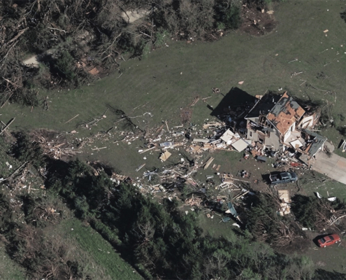
vexcel2022-05-27 21:18:202026-04-14 15:30:15Aerial Imagery for Catastrophic Weather
https://vexceldata.com/wp-content/uploads/2022/05/Tornado_Andover-_US-KS-9.jpeg
576
1024
vexcel
https://vexceldata.com/wp-content/uploads/2021/12/VEXCEL-Data-Program.png
vexcel2022-05-27 21:18:202026-04-14 15:30:15Aerial Imagery for Catastrophic Weather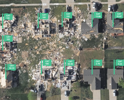 https://vexceldata.com/wp-content/uploads/2022/05/Screen-Shot-2022-05-20-at-11.15.12-AM.png
532
711
vexcel
https://vexceldata.com/wp-content/uploads/2021/12/VEXCEL-Data-Program.png
vexcel2022-05-20 20:01:342022-05-22 17:14:56Announcing Elements: Damage Assessment – Catastrophe Analytics
https://vexceldata.com/wp-content/uploads/2022/05/Screen-Shot-2022-05-20-at-11.15.12-AM.png
532
711
vexcel
https://vexceldata.com/wp-content/uploads/2021/12/VEXCEL-Data-Program.png
vexcel2022-05-20 20:01:342022-05-22 17:14:56Announcing Elements: Damage Assessment – Catastrophe Analytics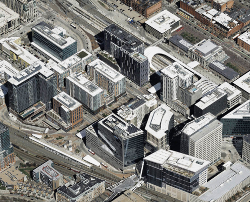 https://vexceldata.com/wp-content/uploads/2022/02/Denver_CO_oblique_39.754691_-105.002128-1-1030x573-copy-1.jpg
720
1280
vexcel
https://vexceldata.com/wp-content/uploads/2021/12/VEXCEL-Data-Program.png
vexcel2022-02-11 21:33:572026-04-14 15:49:46Geo Week 2022 Showcases New SDK, Growing Imagery Library, and Integration Updates
https://vexceldata.com/wp-content/uploads/2022/02/Denver_CO_oblique_39.754691_-105.002128-1-1030x573-copy-1.jpg
720
1280
vexcel
https://vexceldata.com/wp-content/uploads/2021/12/VEXCEL-Data-Program.png
vexcel2022-02-11 21:33:572026-04-14 15:49:46Geo Week 2022 Showcases New SDK, Growing Imagery Library, and Integration Updates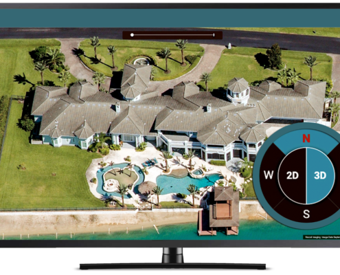 https://vexceldata.com/wp-content/uploads/2021/04/Screen-Shot-2021-04-28-at-3.28.56-PM.png
808
1326
vexcel
https://vexceldata.com/wp-content/uploads/2021/12/VEXCEL-Data-Program.png
vexcel2021-04-29 14:59:452026-04-14 15:55:39Your VIEW Just Got an Upgrade – New Updates to VIEWER
https://vexceldata.com/wp-content/uploads/2021/04/Screen-Shot-2021-04-28-at-3.28.56-PM.png
808
1326
vexcel
https://vexceldata.com/wp-content/uploads/2021/12/VEXCEL-Data-Program.png
vexcel2021-04-29 14:59:452026-04-14 15:55:39Your VIEW Just Got an Upgrade – New Updates to VIEWER